Approximate Location Map
Large Map »
Latitude: 53.5673 / 53°34'2"N
Longitude: -0.0857 / 0°5'8"W
OS Eastings: 526875
OS Northings: 409554
OS Grid: TA268095
Mapcode National: GBR WWV5.7Z
Mapcode Global: WHHHS.NLDM
Plus Code: 9C5XHW87+WP
Entry Name: West Haven Maltings and Garth Buildings
Listing Date: 28 February 1975
Last Amended: 30 June 1999
Grade: II
Source: Historic England
Source ID: 1379841
English Heritage Legacy ID: 479275
ID on this website: 101379841
Location: Grimsby, North East Lincolnshire, DN31
County: North East Lincolnshire
Electoral Ward/Division: West Marsh
Parish: Non Civil Parish
Built-Up Area: Grimsby
Traditional County: Lincolnshire
Lieutenancy Area (Ceremonial County): Lincolnshire
Church of England Parish: Great Grimsby St Mary and St James
Church of England Diocese: Lincoln
Tagged with: Architectural structure
GRIMSBY
TA2609NE GARTH LANE
699-1/16/36 (South side)
28/02/75 West Haven Maltings and Garth
Buildings
(Formerly Listed as:
GARTH LANE
(South side)
Flour Mill, Barley Kiln, Maltings
and Warehouse)
GV II
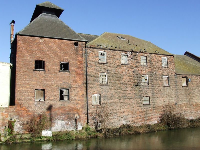
Maltings and warehouses, now partly occupied by shop and
sports clubs. Late C18 maltings and warehouse range, with
later C19 barley kiln and loading-bay ranges. Brown and red
brick. C20 slate roof to kiln range, C20 weatherboarded north
gable and concrete tile roof to maltings range; original Welsh
slate roof to loading-bay range. Rectangular on plan, fronting
the West Haven on the south and Garth Lane to the north, with
kiln range at west end.
EXTERIOR: 2 and 3 storeys. South side: tall 2-storey, 2-window
kiln range to far left has pair of ground-floor windows, one
with plain glazing beneath a segmental brick arch, the other a
later alteration with 4 panes in a wood surround. Smaller
first-floor windows with stone sills and segmental arches, one
with 3 vertical lights, the other with plain glazing. Tall
hipped roof with hipped ventilator section on top.
Garth Lane front has inserted C20 garage door to right, a
single ground-floor window and a pair of first-floor windows
similar to those on the south riverside frontage.
Adjoining to the east is a long range with irregular
fenestration, approximately 16 bays; originally 2 storeys
throughout, the western 4-window section (adjoining the kiln
to the left) raised to 3 storeys. South river front: large
double loading doors beneath lintel, first-floor loading door
to right. Windows of varying size, those to the ground floor
mostly smaller than those to upper storeys, and those to the 7
left bays more regular, with 6 panes; most windows with sills
beneath segmental brick arches. The 3-storey section on the
left has the roof hipped to left and half-hipped to right
above a weatherboarded gable; adjoining 2-storey section has
pitched roof subdivided by a raised brick-coped gable, and
hipped at the right (east) end.
Garth Lane frontage of main range has 2 sets of double board
doors, windows with sills and glazing bars beneath segmental
arches, first-floor door to taller southern section. Adjoining
to the north-east is a single-storey loading-bay range with a
raised double door flanked by single segmental-arched barred
windows; to the left, a large sliding door and a double board
door beneath timber lintels. Stepped eaves, roof hipped to
left. Above the sliding door is an enamel name-plate inscribed
"GARTH BUILDINGS".
The later 2-storey range adjoining to the north is not of
special interest.
INTERIOR: maltings and warehouse range has queen-strut roof
trusses with long tie beams. Interior of barley kiln not
inspected.
HISTORY: West Haven was Grimsby's early port, before the dock
extensions to the north were created from 1800 onwards.
(The Buildings of England: Pevsner N, Harris J, and Antram N:
Lincolnshire: London: 1989-: 341-2; Grimsby - Action for
Conservation: Grimsby Borough Planning Department: List of
buildings of local architectural or historical interest:
Grimsby Borough Council: 1972-: NO.26; Grimsby Borough
Council: Top Town Trail: Grimsby: 1989-: N0.44).
Listing NGR: TA2687509554
External links are from the relevant listing authority and, where applicable, Wikidata. Wikidata IDs may be related buildings as well as this specific building. If you want to add or update a link, you will need to do so by editing the Wikidata entry.


Other nearby listed buildings
