Approximate Location Map
Large Map »
Latitude: 53.2771 / 53°16'37"N
Longitude: -1.7302 / 1°43'48"W
OS Eastings: 418090
OS Northings: 375603
OS Grid: SK180756
Mapcode National: GBR JZCJ.7Y
Mapcode Global: WHCCT.DWBL
Plus Code: 9C5W77G9+RW
Entry Name: Three Stags Head
Listing Date: 23 June 2000
Grade: II
Source: Historic England
Source ID: 1380338
English Heritage Legacy ID: 480324
ID on this website: 101380338
Location: Wardlow Mires, Derbyshire Dales, Derbyshire, SK17
County: Derbyshire
District: Derbyshire Dales
Civil Parish: Wardlow
Traditional County: Derbyshire
Lieutenancy Area (Ceremonial County): Derbyshire
Church of England Parish: Longstone St Giles
Church of England Diocese: Derby
WARDLOW
SK 17 NE Three Stags Head
356/1/10001
23-JUN-00
II
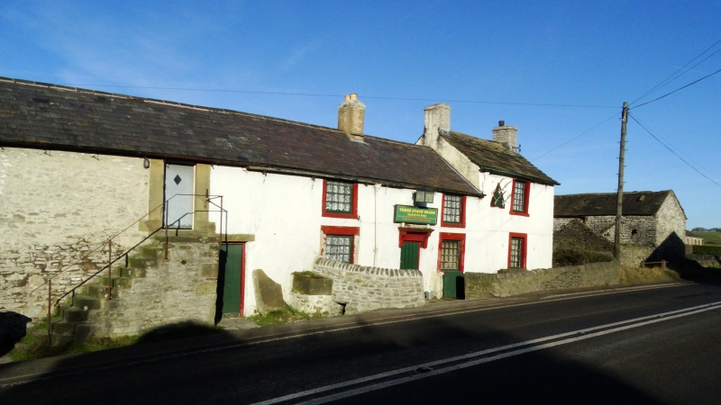
Former farmhouse with attached range of outbuildings, now public house and outbuildings. Mid/late C18 with C19 and C20 alterations and additions.
MATERIALS: rubble limestone with gritstone dressings, house front now with painted roughcast. Coped west gable, and Welsh slate roof coverings to all parts except taller bay to east end which is stone slated. Ridge and end stacks.
PLAN: linear plan with stepped public house part to east end with 3 public bar areas, arranged axially in the building with servery in centre bar. Western part, formerly farm buildings, now store.
EXTERIOR: Public house part 2 storey and 4-bays, east end bay taller, and possibly of later date than the remaining part, and with single small paned window set within painted stone surround to each floor. Lower part with off centre doorway below shallow bracketed hood. Flanking windows with small paned frames set within painted stone surrounds, heads to first floor windows at eaves level. Further to west single ground floor doorway. Attached outbuilding range of 6-bays, single storey with overlofts, and with flight of stone steps to east end, giving access to overloft doorway with massive stone surround. 2 further overloft openings, formerly taking-in doors, now glazed. Off centre ground floor doorway, and blocked door, now window to west end.
INTERIOR: central bar has internal timber porch and stone flagged floor. Hearth with massive deep lintel and moulded mantle shelf carried on jowelled jambs. C19 iron hearth fittings. To right, built-in wall cupboard, with fielded panelled door. 5 stalls in left-hand outbuilding with stone boskins between.
illustrating both its farming use and that of a small, unaltered rural public house.
A well-detailed vernacular farmhouse and outbuilding range, where the house has developed into a public house, being sited on a principal north-south routeway, and retaining a little-altered domestic-scale interior, now a rare survival.
Listing NGR: SK1809075603
External links are from the relevant listing authority and, where applicable, Wikidata. Wikidata IDs may be related buildings as well as this specific building. If you want to add or update a link, you will need to do so by editing the Wikidata entry.


Other nearby listed buildings
