Approximate Location Map
Large Map »
Latitude: 50.8201 / 50°49'12"N
Longitude: -0.1422 / 0°8'31"W
OS Eastings: 530962
OS Northings: 103923
OS Grid: TQ309039
Mapcode National: GBR JP4.DX2
Mapcode Global: FRA B6LX.VV2
Plus Code: 9C2XRVC5+24
Entry Name: Shelter Facing the End of Ship Street
Listing Date: 26 August 1999
Grade: II
Source: Historic England
Source ID: 1381650
English Heritage Legacy ID: 482013
ID on this website: 101381650
Location: Brighton and Hove, West Sussex, BN1
County: The City of Brighton and Hove
Electoral Ward/Division: Regency
Parish: Non Civil Parish
Built-Up Area: Brighton and Hove
Traditional County: Sussex
Lieutenancy Area (Ceremonial County): East Sussex
Church of England Parish: Brighton St Paul
Church of England Diocese: Chichester
BRIGHTON
TQ3003NE KING'S ROAD
577-1/45/364 (South side)
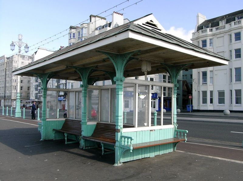
Shelter facing the end of Ship
Street
GV II
Promenade shelter. c1883-7. Cast-iron and wood, roof of metal.
The shelter consists of 6 cast-iron columns with 4 brackets
attached to their upper parts; the 2 inner columns are set
closer together so that their brackets touch, forming a round
arch; the brackets have openwork spandrels. Between these
columns the shelter is framed up with tongue-and-groove
panelling to a height of about 3 feet and then with glazed
panels above, the glazing renewed. Wooden benches possibly of
a date with the shelter fill the spaces between the columns, 2
to each side, facing north and south, and there are additional
smaller seats on brackets at either end, facing east and west.
The underside of the roof is panelled, the roof itself hipped
with louvred gablets.
(Carder T: The Encyclopaedia of Brighton: Lewes: 1990-).
Listing NGR: TQ3096203923
External links are from the relevant listing authority and, where applicable, Wikidata. Wikidata IDs may be related buildings as well as this specific building. If you want to add or update a link, you will need to do so by editing the Wikidata entry.


Other nearby listed buildings
