Approximate Location Map
Large Map »
Latitude: 51.211 / 51°12'39"N
Longitude: -2.6432 / 2°38'35"W
OS Eastings: 355169
OS Northings: 145949
OS Grid: ST551459
Mapcode National: GBR MN.3XVY
Mapcode Global: VH89S.4TJJ
Plus Code: 9C3V6964+9P
Entry Name: 1, St Andrew Street
Listing Date: 12 November 1953
Last Amended: 31 May 2000
Grade: I
Source: Historic England
Source ID: 1383102
English Heritage Legacy ID: 483520
ID on this website: 101383102
Location: St Andrew, Somerset, BA5
County: Somerset
District: Mendip
Civil Parish: Wells
Built-Up Area: Wells
Traditional County: Somerset
Lieutenancy Area (Ceremonial County): Somerset
Tagged with: Building
WELLS
ST5445 ST ANDREW STREET
662-1/7/242 (North side)
12/11/53 No.1
(Formerly Listed as:
VICAR'S CLOSE
(East side)
Nos.1-13 (Consecutive))
GV I
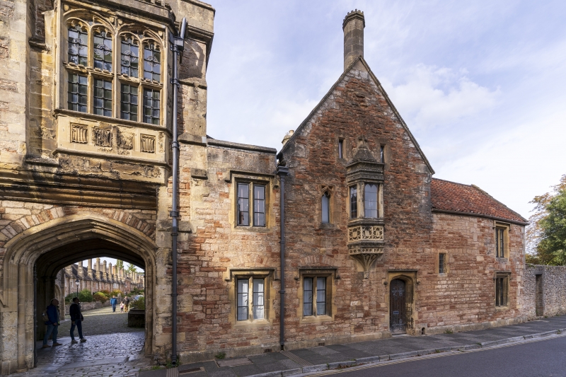
House at end of row, formerly part of No.1, Vicars' Close
(qv). C14 and C15, some later additions. Rubble or coursed and
squared rubble, Doulting ashlar dressings, pantile roofs. The
street front has a central gable, flanked by wings set flush;
that to the left has a parapet, and is shorter than the right
wing, which has a plain eaves roof and return gable end.
EXTERIOR: 2 storeys, windows mainly double-chamfer
stone-mullioned casements with stopped drip courses. The
central gable has a fine canted oriel with crenellated parapet
under a swept cresting with fleur-de-lys, flanked by small
slit openings, and to the left is a small cusped light. At the
ground floor is a 2-light casement, and a C19 door in a
4-centred opening, with stopped drip.
Each wing has a 2-light casement at each floor, and the right
wing has a small stair light immediately to the right of the
main gable. The main gable has a raised coping, which
continues as a parapet to the left, and an octagonal chimney
shaft with crenellated capping.
The return gable to the right is also coped, above plain
rubble walling but with central flush brick flues, cut back
below the ridge.
INTERIOR: not inspected, but likely to retain early structure
and detail, as the house was originally part of No.1, Vicars'
Close, which has a blocked doorway to the party wall at ground
floor level.
Part of an outstanding planned terrace group of the medieval
period.
Listing NGR: ST5516745948
External links are from the relevant listing authority and, where applicable, Wikidata. Wikidata IDs may be related buildings as well as this specific building. If you want to add or update a link, you will need to do so by editing the Wikidata entry.


Other nearby listed buildings
