Approximate Location Map
Large Map »
Latitude: 54.2976 / 54°17'51"N
Longitude: -2.4956 / 2°29'44"W
OS Eastings: 367842
OS Northings: 489224
OS Grid: SD678892
Mapcode National: GBR CL0R.H5
Mapcode Global: WH94B.M7TQ
Plus Code: 9C6V7GX3+2Q
Entry Name: Mire House
Listing Date: 14 June 1984
Last Amended: 18 October 1999
Grade: II
Source: Historic England
Source ID: 1383920
English Heritage Legacy ID: 484352
ID on this website: 101383920
Location: Westmorland and Furness, Cumbria, LA10
County: Cumbria
District: South Lakeland
Civil Parish: Dent
Traditional County: Yorkshire
Lieutenancy Area (Ceremonial County): Cumbria
Church of England Parish: Dent with Cowgill
Church of England Diocese: Carlisle
Tagged with: House
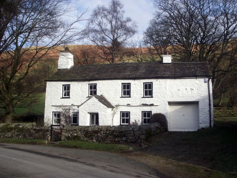
DENT
SD68NE DENTDALE
162-1/10/122 (North side)
14/06/84 Mire House
(Formerly Listed as:
DENTDALE
Mire House and Barn to south-east)
GV II
Farmhouse, now dwelling. Probably late C17 or early C18
(though dated 1635 on porch); extended and altered.
White-painted random rubble with quoins; stone slate roof.
Single-depth 2-unit plan on east-west axis facing south,
full-height outshut added to rear and 1-bay extension at east
end.
EXTERIOR: 2 storeys and 4 windows, almost symmetrical (except
for the extension); with a stone slate drip-course over the
ground floor. The ground floor has a gabled porch in the
centre, with a square-headed doorway, panelled door and C20
datestone inscribed "1635"; a square window to the left, now
furnished with 2-light top-hung casements, and a small 4-pane
sash to the left of that (formerly a fire-window); and two
similar 4-pane sashes to the right. The 1st floor has 4
similar small sashes almost symmetrically arranged. Large
corbelled chimney at left gable; ridge chimney at junction to
right. Full-height extension to right now has garage door at
ground floor, and no opening above. Rear: added full-height
outshut containing staircase and former dairy.
INTERIOR: chamfered lateral beams; spice-cupboard with fielded
panel door in housepart to left. Housepart and dairy now
knocked into one; staircase altered.
Forms group with barn approx. 3m to east (qv).
Listing NGR: SD6784289224
External links are from the relevant listing authority and, where applicable, Wikidata. Wikidata IDs may be related buildings as well as this specific building. If you want to add or update a link, you will need to do so by editing the Wikidata entry.


Other nearby listed buildings
