Approximate Location Map
Large Map »
Latitude: 53.514 / 53°30'50"N
Longitude: -2.2475 / 2°14'51"W
OS Eastings: 383684
OS Northings: 401954
OS Grid: SD836019
Mapcode National: GBR DJ3.1B
Mapcode Global: WHB98.FXZZ
Plus Code: 9C5VGQ72+JX
Entry Name: Synagogue
Listing Date: 20 October 1998
Grade: II
Source: Historic England
Source ID: 1385841
English Heritage Legacy ID: 471260
ID on this website: 101385841
Location: Higher Crumpsall Synagogue, Broughton Park, Salford, Greater Manchester, M7
County: Salford
Electoral Ward/Division: Kersal
Parish: Non Civil Parish
Built-Up Area: Salford
Traditional County: Lancashire
Lieutenancy Area (Ceremonial County): Greater Manchester
Church of England Parish: Crumpsall St Thomas with Cheetham St Mark
Church of England Diocese: Manchester
Tagged with: Synagogue
SALFORD
SD80SW BURY OLD ROAD
949-1/2/30 (North side)
Synagogue
II
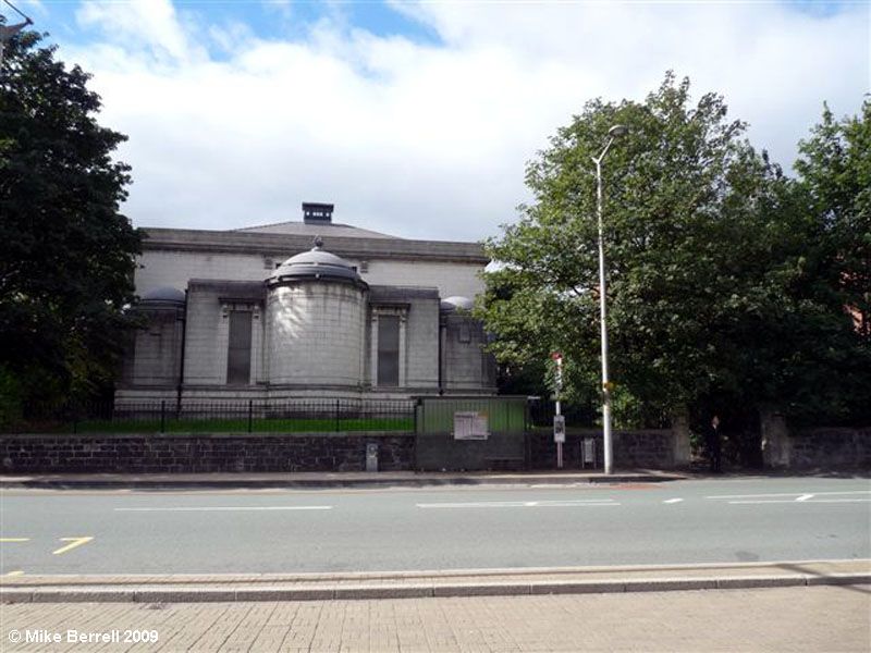
Synagogue. Dated on foundation stones 1928-29. White ashlar
facing, pink brick with stone dressings to side and rear.
Hipped Welsh slate roof with central lantern. Modern
Neo-classical style. Main body of synagogue to E with Ark in
elevation to Old Bury Road and entrance in SE elevation.
Offices, hall and staircase block of less height to W.
EXTERIOR: galleried main body of synagogue expressed as 2
storeys, the SE elevation of 5 bays with high rusticated
plinth and stripped down Corinthian pilasters. Facade further
articulated by full-height moulded panels to windows, which
are round-arched in upper storey. Simply detailed cornice
above. Entrance to left in projecting bay: paired doors
beneath entablature carried on console brackets.
Opposing elevation similarly fenestrated, but plainer: pink
brick with stone dressings and no decorative detail.
Elevation to Bury Old Road has advanced central bay, from
which the segmentally planned and domed Ark projects. Above it
a tripartite window with entablature, and windows with
entablatures above each side. Lions' head decoration in
cornice of ark. Each side of advanced central bay, lower domed
blocks house entrances in side elevations, with plain, narrow
tripartite windows over. Hall and office range towards west
pink brick with stone dressings. Paired doors alongside main
entrance, and central paired doors in recessed central bay of
SW elevation. This is flanked by tripartite windows in the
outer bays, lighting stairway, the central light segmentally
arched to top and bottom.
INTERIOR: the main body of the synagogue retains its original
fittings. Oak seating to ground floor and galleries on three
sides; marble Bimah with copper rails and light fittings;
marble dais with copper rails, and curved sliding doors to
ark.
Listing NGR: SD8368401954
External links are from the relevant listing authority and, where applicable, Wikidata. Wikidata IDs may be related buildings as well as this specific building. If you want to add or update a link, you will need to do so by editing the Wikidata entry.


Other nearby listed buildings
