Approximate Location Map
Large Map »
Latitude: 53.4929 / 53°29'34"N
Longitude: -2.2841 / 2°17'2"W
OS Eastings: 381246
OS Northings: 399612
OS Grid: SJ812996
Mapcode National: GBR D8B.4W
Mapcode Global: WH989.WGHM
Plus Code: 9C5VFPV8+58
Entry Name: The Maypole
Listing Date: 18 February 1998
Grade: II
Source: Historic England
Source ID: 1386098
English Heritage Legacy ID: 471522
Also known as: Maypole
The Maypole, Pendleton, Salford
ID on this website: 101386098
Location: Pendleton, Salford, Greater Manchester, M6
County: Salford
Electoral Ward/Division: Irwell Riverside
Parish: Non Civil Parish
Built-Up Area: Salford
Traditional County: Lancashire
Lieutenancy Area (Ceremonial County): Greater Manchester
Church of England Parish: Pendleton and Claremont
Church of England Diocese: Manchester
Tagged with: Pub
This list entry was subject to a Minor Amendment on 09/10/2017
SJ 8199 NW
949-1/13/23
SALFORD
BROUGHTON ROAD (north-west side)
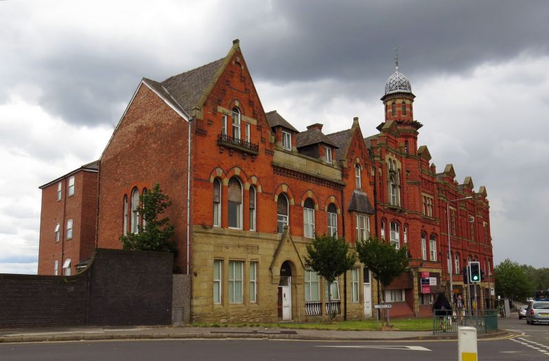
No 9, The Maypole
(Formerly Listed as: Maypole Public House, BROUGHTON ROAD)
18/02/98
GV
II
Former public house. c1860. Brick with stone dressings and Welsh slate roof. Two storeys, five window range with outer gables. Gothic style. Stone-faced ground storey, with main doorway to left of centre in expressed gabled porch, three-light mullioned window to left and renewed paired windows to right, with subsidiary doorway below right hand gable. Flat oriel window in right hand gable of first floor and round-arched window in the apex above.Three arched windows with polychrome brick heads in central section, with corbelling to stone eaves parapet above, and two hipped gabled dormers over. Triple round-arched windows with polychrome dressings in left hand gable, and stepped lights in apex with cast-iron balconette carried on corbels. Each gable has shallow corbelled decoration and stone copings.Truncated end wall stacks.
This building makes an important contribution to the setting of other buildings on this street.
Listing NGR: SJ8124699612
External links are from the relevant listing authority and, where applicable, Wikidata. Wikidata IDs may be related buildings as well as this specific building. If you want to add or update a link, you will need to do so by editing the Wikidata entry.


Other nearby listed buildings
