Approximate Location Map
Large Map »
Latitude: 51.8907 / 51°53'26"N
Longitude: -2.087 / 2°5'13"W
OS Eastings: 394108
OS Northings: 221351
OS Grid: SO941213
Mapcode National: GBR 2MB.F5P
Mapcode Global: VH947.SQ1Z
Plus Code: 9C3VVWR7+75
Entry Name: Cleevelands (Numbers 25)
Listing Date: 14 December 1983
Grade: II
Source: Historic England
Source ID: 1388161
English Heritage Legacy ID: 476159
ID on this website: 101388161
Location: Tivoli, Cheltenham, Gloucestershire, GL50
County: Gloucestershire
District: Cheltenham
Electoral Ward/Division: Park
Parish: Non Civil Parish
Built-Up Area: Cheltenham
Traditional County: Gloucestershire
Lieutenancy Area (Ceremonial County): Gloucestershire
Church of England Parish: Cheltenham St Stephen
Church of England Diocese: Gloucester
Tagged with: Architectural structure
CHELTENHAM
SO9421SW TIVOLI ROAD
630-1/22/965 (West side)
14/12/83 Nos.23 AND 25
Cleevelands (No.25)
GV II
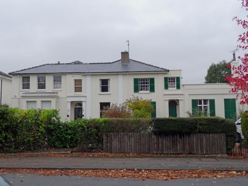
Pair of semi-detached villas. c1834-50 with later additions
and alterations. Stucco over brick with hipped slate roof,
off-centre right stucco ridge stack.
EXTERIOR: 2 storeys, 7 first-floor widows (5:2) with
single-storey, 2-window range to right. Stucco detailing
includes Doric pilasters to right of 4th window, 2 pilasters
to right of 5th window, one to right of 6th window. 6/6 sashes
with margin-lights and 2/2 horizontal-pane sashes with
margin-lights where original; ground-floor range at right has
6-pane French windows with divided overlight, all with
margin-lights; to ground-floor at left a rectangular bay;
Venetian shutters to house to right. All in plain reveals and
with sills. Entrances below 4th and 7th windows: 4-panel,
part-glazed doors with fanlights in pilastered surround with
frieze and cornice.
INTERIOR: not inspected.
HISTORICAL NOTE: houses on Tivoli Road (originally Tivoli) are
shown as laid out on Merrett's 1834 Map.
Listing NGR: SO9410321347
External links are from the relevant listing authority and, where applicable, Wikidata. Wikidata IDs may be related buildings as well as this specific building. If you want to add or update a link, you will need to do so by editing the Wikidata entry.


Other nearby listed buildings
