Approximate Location Map
Large Map »
Latitude: 53.3065 / 53°18'23"N
Longitude: -2.3738 / 2°22'25"W
OS Eastings: 375186
OS Northings: 378900
OS Grid: SJ751789
Mapcode National: GBR CZV6.WF
Mapcode Global: WH997.H5T1
Plus Code: 9C5V8J4G+HF
Entry Name: Former Barclays Bank
Listing Date: 24 July 1992
Grade: II
Source: Historic England
Source ID: 1388384
English Heritage Legacy ID: 476394
ID on this website: 101388384
Location: Knutsford, Cheshire East, Cheshire, WA16
County: Cheshire East
Civil Parish: Knutsford
Built-Up Area: Knutsford
Traditional County: Cheshire
Lieutenancy Area (Ceremonial County): Cheshire
Church of England Parish: Knutsford St John the Baptist
Church of England Diocese: Chester
Tagged with: Bank building
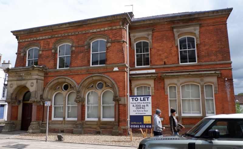
KNUTSFORD
SJ7478 KING STREET
792-1/3/67 (East side)
24/07/92 No.127
Former Barclays Bank
GV II
Formerly known as: Union Bank KING STREET.
Bank. Purpose-built 1856. Brick with stone dressings and Welsh
slate roof.
2 storeys; 5-window range, with shallow hipped roofed wing
projecting to the left. Main entrance to left in this wing, in
heavy stone porch, the round-arched entrance carried on squat
marble columns and surmounted by deep entablature. Heavy
arcading to paired windows to right, the deep round arches
carried on marble shafts. Recessed plate traceried windows.
Secondary doorway to left of right-hand block, with stilted
arched entablature. Tripartite sash window alongside, with
stilted entablature. Continuous string course beneath
first-floor windows which are all sashes in stilted arches,
the hoodmould continuous in the left-hand wing, the right-hand
windows stressed with entablature hoods. Heavy moulded stone
eaves cornice. Axial stack.
INTERIOR: not inspected.
(The Buildings of England: Pevsner N: Cheshire: Harmondsworth:
1971-).
Listing NGR: SJ7518678900
External links are from the relevant listing authority and, where applicable, Wikidata. Wikidata IDs may be related buildings as well as this specific building. If you want to add or update a link, you will need to do so by editing the Wikidata entry.


Other nearby listed buildings
