Approximate Location Map
Large Map »
Latitude: 53.2228 / 53°13'22"N
Longitude: -0.5435 / 0°32'36"W
OS Eastings: 497340
OS Northings: 370518
OS Grid: SK973705
Mapcode National: GBR FMQ.TPP
Mapcode Global: WHGJ5.M8D5
Plus Code: 9C5X6FF4+4J
Entry Name: Unitarian Chapel
Listing Date: 15 August 1973
Last Amended: 13 June 2022
Grade: II
Source: Historic England
Source ID: 1388606
English Heritage Legacy ID: 486051
ID on this website: 101388606
Location: New Boultham, Lincoln, Lincolnshire, LN5
County: Lincolnshire
District: Lincoln
Electoral Ward/Division: Park
Parish: Non Civil Parish
Built-Up Area: Lincoln
Traditional County: Lincolnshire
Lieutenancy Area (Ceremonial County): Lincolnshire
Church of England Parish: Lincoln St Peter-at-Gowts
Church of England Diocese: Lincoln
Tagged with: Chapel
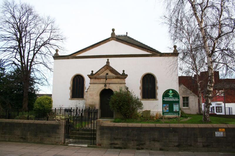
Unitarian Chapel built in 1725.
Unitarian Chapel built in 1725.
MATERIALS: the building is of red brick, rendered to the north, west and south elevations, with limestone dressings and a slate roof covering.
PLAN: the building is rectangular on plan, and faces west onto High Street.
EXTERIOR: the chapel is a single-storey building fronting the High Street within slightly elevated and spacious grounds. The primary-phase, Georgian chapel is a single-cell, rectangular plan under a hipped roof with the main entrance sitting centrally on the west (High Street) elevation. A stone plinth runs the length of the north, west and south elevations. The principal, west elevation contains a central, Jacobean Revival entrance porch in ashlar limestone, with a pediment and entablature over a round-arched doorway with keystone. The porch is flanked by two round-arched, stone windows with later Gothic Revival tracery, surmounted by a moulded cornice and pediment with an orb finial.
The north and south elevations are of matching design, each containing two round-arched, stone windows with later Gothic Revival tracery matching that on the west elevation. The rear (east) elevation of the primary-phase chapel is largely concealed by a C19 extension, which cuts across two round-arched windows with tracery matching the other windows in their unblocked uppermost sections.
The rear (east) extension is a single-storey, red brick structure covering the full width of the original chapel, with a ridge chimney stack rising from the blank, gable end wall. Adjoining this extension to the south is a later extension of the early C20. It is of orange-red brick under a pitched roof and rendered on its south and west elevations. There is a doorway and casement window on the west elevation with leaded lights, and a blocked-in window on the south elevation.
INTERIOR: it is understood that the interior has a moulded band and cornice, and two central, wooden Doric piers. The ceiling has renewed plaster bosses and there is painted decoration on the north wall. Fittings include an oak corner pulpit and communion table, and plain benches. Memorials include a wooden war memorial board, of around 1920.
Listing NGR: SK9734070518
Lincoln High Street is part of the major Roman road, Ermine Street, linking London to York. It has served as the principal route into the city from the south since the first century when a legionary fortress was established on what is now ‘Uphill’ Lincoln (the vicinity of the cathedral and castle). The fortress was later transformed into a civilian settlement, taking the name Colonia Lindum, from which its modern name is derived. The Roman town gradually expanded south along Ermine Street beyond the River Witham. This development pattern was largely re-established after the Vikings resettled the city during the C9. By the time of the Norman Conquest, both sides of Ermine Street appear to have been developed for some distance south of the river, but as late as the C18, development to the east and west of the High Street was mostly limited to the areas of the castle and cathedral in ‘Uphill’ Lincoln and along the riverfront in ‘Downhill’ Lincoln.
The land south of the River Witham witnessed considerable industrial and commercial growth during the late-C18 and C19. The land to the east and west of the High Street was transformed into a network of workshops, factories and yards, a trend reinforced by the arrival of the Midland Railway in 1846, followed by the Great Northern Railway in 1848, which transformed a large swathe of the area into a complex of railway buildings, storehouses and sidings. The High Street witnessed gradual redevelopment throughout this period, creating the largely C19 streetscape seen today, although a significant number of pre-industrial buildings have survived, often hidden behind later facades.
The Unitarian Chapel was built in 1725 for a Presbyterian congregation formed in the late C17. The congregation became Unitarian in 1837 and the chapel has remained in use by the Unitarians ever since, apart from a period of disuse between 1902 and 1923.
As built, it was a simple, single-cell, single-storey building. It was altered in 1819 when a porch was added and the brickwork was rendered. The single-storey, rear (eastern) extension may have also been added at this time and was extant by 1887. Further alterations were carried out in 1902, although the nature of this work is unclear. Sometime between 1904 and 1930, a single-storey, pitched-roofed extension was added to the south of the C19 extension adjoining Monson Street. An extensive restoration of the chapel was carried out in 1987.
Legacy Record – This information may be included in the List Entry Details.
External links are from the relevant listing authority and, where applicable, Wikidata. Wikidata IDs may be related buildings as well as this specific building. If you want to add or update a link, you will need to do so by editing the Wikidata entry.


Other nearby listed buildings
