Approximate Location Map
Large Map »
Latitude: 53.233 / 53°13'58"N
Longitude: -0.5323 / 0°31'56"W
OS Eastings: 498062
OS Northings: 371672
OS Grid: SK980716
Mapcode National: GBR FMQ.B78
Mapcode Global: WHGHZ.SZPV
Plus Code: 9C5X6FM9+63
Entry Name: Lindum Holme Lodge and Attached Gateway
Listing Date: 8 October 1953
Last Amended: 20 December 1999
Grade: II
Source: Historic England
Source ID: 1388628
English Heritage Legacy ID: 486073
ID on this website: 101388628
Location: Lincoln, Lincolnshire, LN2
County: Lincolnshire
District: Lincoln
Electoral Ward/Division: Abbey
Parish: Non Civil Parish
Built-Up Area: Lincoln
Traditional County: Lincolnshire
Lieutenancy Area (Ceremonial County): Lincolnshire
Church of England Parish: Lincoln St Peter-in-Eastgate with St Margaret in the close
Church of England Diocese: Lincoln
Tagged with: Architectural structure
LINCOLN
SK9871NW LINDUM ROAD
1941-1/10/207 (East side)
08/10/53 Lindum Holme Lodge and attached
gateway
GV II
Formerly known as: Lodge to Lindum Holme LINDUM ROAD.
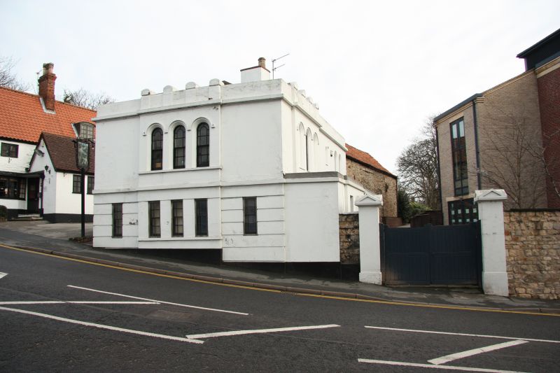
Former lodge, now a house. Early C19, with late C20
alterations. Dressed stone and stucco with hipped and
pyramidal slate roofs and a ridge stack.
Plinth, channelled rusticated ground floor, first floor and
eaves bands, parapet. 2 storeys, 2 bays.
West front, to street, has a slightly projecting centre with 3
margin light sashes and above, 3 similar sashes with round
heads and hoodmoulds. On the parapet, 4 arch topped pedestals.
South side has a single storey full width addition with a
door, flanked to left by 2 blank openings and to right by a
blank opening and a C20 window. Above, to the left, a
projection with a round headed margin light sash, flanked by
single blank openings with hoodmoulds. Above them, 4
pedestals. To the right, 3 round headed windows.
INTERIOR not inspected.
Outside, to the south, a pair of square gatepiers, rendered,
with pyramidal caps.
Listing NGR: SK9806271672
External links are from the relevant listing authority and, where applicable, Wikidata. Wikidata IDs may be related buildings as well as this specific building. If you want to add or update a link, you will need to do so by editing the Wikidata entry.


Other nearby listed buildings
