Approximate Location Map
Large Map »
Latitude: 53.2373 / 53°14'14"N
Longitude: -0.5381 / 0°32'17"W
OS Eastings: 497667
OS Northings: 372137
OS Grid: SK976721
Mapcode National: GBR FMQ.2SD
Mapcode Global: WHGHZ.PWZL
Plus Code: 9C5X6FP6+WQ
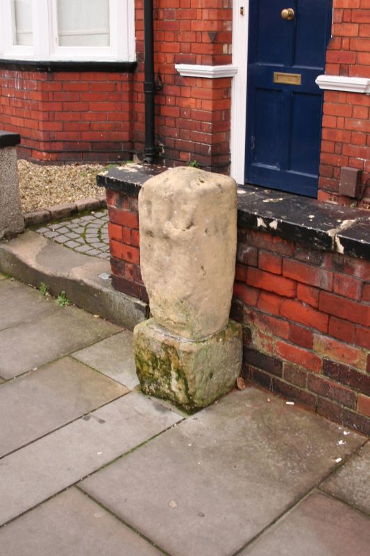
Entry Name: Boundary Stone 15 Metres North of the Newport Arch
Listing Date: 8 July 1991
Grade: II
Source: Historic England
Source ID: 1388725
English Heritage Legacy ID: 486186
ID on this website: 101388725
Location: Lincoln, Lincolnshire, LN1
County: Lincolnshire
District: Lincoln
Electoral Ward/Division: Minster
Parish: Non Civil Parish
Built-Up Area: Lincoln
Traditional County: Lincolnshire
Lieutenancy Area (Ceremonial County): Lincolnshire
Church of England Parish: Lincoln St Nicholas
Church of England Diocese: Lincoln
Tagged with: Boundary marker
LINCOLN
SK9772SE NEWPORT
1941-1/7/298 (East side)
08/07/91 Boundary stone 15m north of the
Newport Arch
GV II
Boundary stone. c1735. Ashlar. Square post approx. 1m high,
with remains of the City arms on the west side.
Listing NGR: SK9766772137
External links are from the relevant listing authority and, where applicable, Wikidata. Wikidata IDs may be related buildings as well as this specific building. If you want to add or update a link, you will need to do so by editing the Wikidata entry.


Other nearby listed buildings
