Approximate Location Map
Large Map »
Latitude: 52.9767 / 52°58'36"N
Longitude: -0.0228 / 0°1'22"W
OS Eastings: 532855
OS Northings: 343980
OS Grid: TF328439
Mapcode National: GBR JWH.737
Mapcode Global: WHHLQ.MFCT
Plus Code: 9C4XXXGG+MV
Entry Name: 6 and 8 South Street, Pilgrim House
Listing Date: 27 May 1949
Last Amended: 8 December 2011
Grade: II
Source: Historic England
Source ID: 1388999
English Heritage Legacy ID: 486461
ID on this website: 101388999
Location: Boston, Lincolnshire, PE21
County: Lincolnshire
District: Boston
Electoral Ward/Division: Trinity
Parish: Non Civil Parish
Built-Up Area: Boston
Traditional County: Lincolnshire
Lieutenancy Area (Ceremonial County): Lincolnshire
Church of England Parish: Boston St Botolph
Church of England Diocese: Lincoln
Tagged with: Building
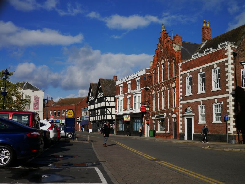
A mid-C17 building, now offices, altered in the late C18, C19 and C20.
MATERIALS: Red brick with stucco bands and dressings, a stone plinth and hipped, slate-covered roof.
PLAN: The building is rectangular, of three storeys, the west elevation of three bays.
EXTERIOR: The ground floor of the west elevation has a C19-style shop front, with a plain fascia and central double doors with fielded panels and overlight, flanked by panelled sections with reeded pilasters. The shop windows are divided into lights with pointed arches. Between the ground, first and second floors are sill bands: between the ground and first are two, one broad and one narrow, and between the first and second, one narrow band. The first and second floors have three windows each. The first floor has a plain sash flanked by C19 canted oriel windows, with plain sashes, pilasters, panelled bases and deep cornices surmounted by wrought-iron rails. The second floor windows are six-paned, unhorned sashes; both these and the central window to the first floor have rusticated lintels with keystones.
The sill bands come to an end in the north elevation on Shodfriars Lane at the point where there is a clear change in the brickwork. All windows in this elevation are unhorned sashes, that to the ground floor tripartite. A side entrance has a wooden doorcase with plain pilasters and cornice, the door recessed, with a plain overlight. There are two similar doors in the east elevation, side by side, with moulded doorcases and cornices, that to the north recessed, that to the south reached by a ramp for wheelchair access, under a large modern canopy. There are four unhorned, three-over-six-paned sash windows to the second floor of this elevation, three of which are aligned with the first-floor margin light sashes and with the ground floor windows, the latter large tripartite sash windows, that to the south plain, that to the north with glazing bars, and with lintels with keystones. The first and second floor windows have segmental arches. The south elevation has an irregular arrangement of sash windows, both horned and unhorned, to all three floors.
INTERIOR: The extensive cellars are largely constructed of brick, and contain substantial chamfered beams, some with run-out stops, some with evident signs of reuse. The interior on all floors has been extensively remodelled. However, elements of historic detail survive, most notably an C18 staircase with turned balusters and plain, square newel post, lit by a tall south facing window between first and second floors. Other detail includes a safe on the ground floor, with double doors containing an ogee arched panel, and a manufacturers brass plaque, as well as cornices, deep moulded skirting boards and six-panelled doors with deep, moulded surrounds. Much of the original roof structure survives, including rafters and ridge piece, augmented by more modern work.
Despite some fluctuation in its fortunes Boston remained a prosperous port and market town from the middle ages into the C19, its social, economic and political history reflected in its town plan and buildings. From the C12 to the C15 it was one of the busiest ports in England, its wealth based principally on the trade in wool, cloth and luxury goods. Boston's market was first recorded between 1125 and 1135, and the annual fair was one of the great trade fairs of Europe. The medieval town grew around streets on either side of the River Witham, now the High Street to the west and South Street to the east. The latter opens to a wide market place to the north, from which narrow medieval lanes travel east and north to Church Street, St Botolph's Church and Wormgate.
The medieval period is represented by fragments of the Dominican friary surviving as the Blackfriars Arts Centre (Grade II*) on Spain Lane, the only visible evidence of the four friaries established in the town in the C12 and C13. Evidence of the town's thriving C14 and C15 engagement in the North Sea wool trade survives in the Guildhall (Grade I) of the Guild of St Mary, one of several religious guilds in the town at this period. Following the incorporation of Boston as a borough in 1545 and the dissolution of the religious guilds two years later, the assets of the Guild of St Mary, including the Guildhall, were transferred to the Corporation. Later C18 fen drainage and the construction of the Grand Sluice realised the value of the Corporation's estate, the increase in income funding significant building projects in the town, including the Exchange Buildings of 1770-1772 (formerly the Corporation Buildings) to the west of the Market Place (Grade II*). This renewed prosperity continued into the first half of the C19, when agricultural enclosure generated new wealth from a now highly productive rural hinterland. The corporation invested in further public building, notably the Assembly Rooms, completed in 1822 (Grade II*) to the north of the Exchange Buildings. The Grade II listed buildings that form an irregular terrace, 42-50 Market Place, also date to the first half of the C19, as do eight Grade II listed warehouses. Between the mid-C18 and mid-C19 the town's suburbs grew to the north-west and east of the Market Place, with limited development to the west of the river.
Boston continued to thrive economically until the construction of the railway in 1848; this brought a station and growth to the west of the town, but withdrew outgoing goods from the port. A new dock constructed by the corporation to the south of the town in 1884 renewed seaborne trade and brought development to an area of previously agricultural land. By the late C19 the town had reached almost its present extent. Although there was new building within the town in the C20, notably the construction of the inner ring road, John Adams Way, much historic fabric has been retained; this is reflected in the comprehensive coverage of Boston in the National Heritage List for England.
6-8 South Street, known as Pilgrim House, is on, or immediately to the north of, the site of the Dominican Friary, founded soon after 1221. The site of the friary occupied about five acres between Shodfriars Lane and Spain Lane. Substantial fragments can be seen in both the exterior and interior of 10 South Street, immediately to the south, in its north elevation and across its ground floor, while more complete remains survive to the south of Spain Lane, restored and remodelled in the mid-C20 as the Blackfriars Arts Centre, listed at Grade II*.
High up on the second floor of the rear, east, elevation of 6-8 South Street are two plaques, one with the initials TTE and the date 1662, and the second with a coat of arms. The building seems to have been remodelled externally in the C18, with new sash windows added to both front and back, and again in the C19 when the front seems to have been substantially rebuilt with the addition of oriel windows to the first floor. The interior was extensively renovated in the C20.
* Historical interest: It reflects the history of Boston’s social and commercial development from the late C17, the late C18 or early C19 remodelling of its east elevation representing a period in the town’s history when it sought to re-establish its commercial pre-eminence as both port and market centre.
* Architectural interest: It retains much of its external detail, with each phase of its development clearly represented. Some indicative elements of internal detail also survive, and the building continues to form part of the varied architecture of the Boston’s historic centre.
External links are from the relevant listing authority and, where applicable, Wikidata. Wikidata IDs may be related buildings as well as this specific building. If you want to add or update a link, you will need to do so by editing the Wikidata entry.


Other nearby listed buildings
