Approximate Location Map
Large Map »
Latitude: 52.1965 / 52°11'47"N
Longitude: -2.223 / 2°13'22"W
OS Eastings: 384853
OS Northings: 255387
OS Grid: SO848553
Mapcode National: GBR 1G4.8SJ
Mapcode Global: VH92T.F14Z
Plus Code: 9C4V5QWG+JQ
Entry Name: 35, Foregate Street
Listing Date: 5 April 1971
Last Amended: 5 July 2001
Grade: II
Source: Historic England
Source ID: 1389812
English Heritage Legacy ID: 488763
ID on this website: 101389812
Location: Worcester, Worcestershire, WR1
County: Worcestershire
District: Worcester
Electoral Ward/Division: Cathedral
Parish: Non Civil Parish
Built-Up Area: Worcester
Traditional County: Worcestershire
Lieutenancy Area (Ceremonial County): Worcestershire
Church of England Parish: Worcester St Nicholas and All Saints
Church of England Diocese: Worcester
Tagged with: Building
WORCESTER
SO8455SE FRIAR STREET
620-1/12/254 (West side)
05/04/71 No.35
GV II
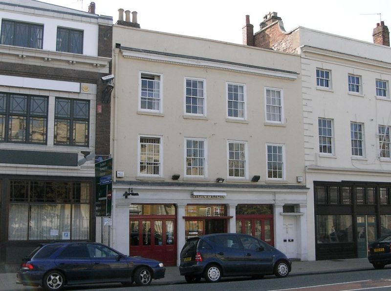
House, now wine bar. Mid C18 with later additions and
alterations including those to ground-floor of mid C20. Stucco
over brick with concealed roof and brick left ridge and right
end stacks with oversailing courses and pots. 3 storeys, 4
first-floor windows. 6/6 sashes to first and second floors in
near-flush frames and with sills. Dentil cornice and coped
parapet. Ground floor as end and off-centre Doric pilasters, 3
pairs of part-glazed doors with overlights and continuous
entablature.
INTERIOR: upper floor not seen, otherwise remodelled mid C20.
HISTORICAL NOTE: during the C18 Foregate Street was known as
'the mall' and Tymbs' Worcester Guide of 1802 notes, 'the
Foregate Street itself, by being paved and sufficiently broad
to admit a full circulation of air seems to be generally
resorted to as a fashionable promenade.'
The Shire Hall, Statue of Queen Victoria, City Museum and
Library, and Nos 15, 19, 22, 23, 24, 28, Nos 33-46
(consecutive) and No.49, Foregate Street (qqv) form a
significant group.
(Worcestershire Historical Society Occasional Papers:
Whitehead D: Urban Renewal and Suburban Growth: The Shaping of
Georgian Worcester: 1989-: 12; Tymbs: Worcester Guide:
Worcester: 1802-: 60).
External links are from the relevant listing authority and, where applicable, Wikidata. Wikidata IDs may be related buildings as well as this specific building. If you want to add or update a link, you will need to do so by editing the Wikidata entry.


Other nearby listed buildings
