Approximate Location Map
Large Map »
Latitude: 52.1905 / 52°11'25"N
Longitude: -2.219 / 2°13'8"W
OS Eastings: 385125
OS Northings: 254717
OS Grid: SO851547
Mapcode National: GBR 1G4.PSG
Mapcode Global: VH92T.H68L
Plus Code: 9C4V5QRJ+5C
Entry Name: 14, 16 and 18, Friar Street
Listing Date: 22 May 1954
Grade: II*
Source: Historic England
Source ID: 1389840
English Heritage Legacy ID: 488791
ID on this website: 101389840
Location: Worcester, Worcestershire, WR1
County: Worcestershire
District: Worcester
Electoral Ward/Division: Cathedral
Parish: Non Civil Parish
Built-Up Area: Worcester
Traditional County: Worcestershire
Lieutenancy Area (Ceremonial County): Worcestershire
Church of England Parish: Worcester St Nicholas and All Saints
Church of England Diocese: Worcester
Tagged with: Building
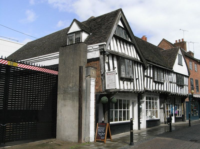
WORCESTER
SO8554NW FRIAR STREET
620-1/17/284 (West side)
22/05/54 Nos.14, 16 AND 18
GV II*
2 houses, now 3 shops with salon over south and centre bays.
Numbered right to left, described left to right. North and
centre bays (Nos 14 and 16) originally one dwelling, probably
for John Watters, c1526-1544; southern bay (No.18) probably
c1536-75; with later additions and alterations including
outshut to rear at south probably late C17 and restorations of
1956 and shop fronts c1980s. Timber frame with brick and
stucco infill, plain tile roof, old tiles to front with
replacements to rear.
PLAN: (Nos 14 and 16) originally a single, two-bay structure,
the north bay slightly larger, with cross passage between in
centre bay, then to south a single-bay dwelling, three bays
deep, with cross passage at south. Now U-form with range at
rear north (right) extended.
EXTERIOR: 2 storeys, with attics to outer gables, 3 bays.
Jowled posts at ground-floor to cross passages and between
dwellings. First-floor is jettied, the bressumer beam is now
in 3 parts; close studding to first floor and to attic at
south, to centre and north parts there is an additional mid
rail and to south bay a bressumer over first-floor;
ground-floor now occupied by shop fronts. Northernmost cross
passage has rectangular framing. 3 replacement casement
windows on brackets and with leaded lights. To south ( No.18)
a continuous cornice on brackets over first-floor. South gable
has similar 3-leaded-light casement window with continuous
timber sill on brackets and 2-light casement window to north
gable. Ground-floor: replacement shop fronts have multi-paned
windows and glazed entrances. Cambered-arched opening to cross
passage at south, further cross passage has straight-headed
lintel and panel of carved decoration over with quatrefoils
and mouchettes. Roof dormer on south return.
INTERIOR: partition walls have large panels of square and
rectangular framing and close studding; jowled posts to first
floor; diagonal and arch braces; chamfered beams at rear,
south with lamb's tongue stops. Clasped purlin roof to centre
and north bays, similar roof to south bay. To north bay, first
floor are 2 panels of painted decoration (probably mid-late
C16) with scrolling foliate motif 'found and restored 1956'.
HISTORICAL NOTE: the gable to north bay is a later addition as
originally this dwelling had a simple roof parallel to
the street, without dormers or gables. Nos 14 and 16
(originally one house) belonged to John Watters "paynter",
526-44; Gyles Taylor lived there in 1660 when the house is
recorded as having 5 hearths; by 1678 Richard Roberts was the
tenant (he became a Quaker); then Thomas Biddle; by 1741 when
it was sold by the Wyldes, the property had been divided at
the rear into 3 cottages and a frontage.
Friar Street originated as a rear access lane for buildings on
High Street until the foundation of the Franciscan Friary in
1235. The first friary buildings occupied the stretch between
Nos 11-25. The south end of the street as developed first,
with plots dating from the mid C14, plots at the north end
date from the early C15. Many of the existing houses date from
the Reformation, the Friary having been suppressed in 1539 and
its property sold by the Crown to the Corporation of Worcester
which demolished much for building materials. Building
continued from c1540 onwards, modifications were made to
houses during the C17, whilst the C18 saw the replacement of
several of the older buildings. The street was inhabited
mainly by tradesmen: weavers, clothiers, brewers and
innkeepers; during the C17 Friar Street hosted a concentration
of non-conformists, especially Quakers.
(Hughes P and Molyneux N: Friar Street: 1984-: 32-33; The
Buildings of England: Pevsner N: Worcestershire:
Harmondsworth: 1968-1985: 328).
External links are from the relevant listing authority and, where applicable, Wikidata. Wikidata IDs may be related buildings as well as this specific building. If you want to add or update a link, you will need to do so by editing the Wikidata entry.


Other nearby listed buildings
