Approximate Location Map
Large Map »
Latitude: 52.1896 / 52°11'22"N
Longitude: -2.2186 / 2°13'6"W
OS Eastings: 385155
OS Northings: 254614
OS Grid: SO851546
Mapcode National: GBR 1G4.PX2
Mapcode Global: VH92T.H7H9
Plus Code: 9C4V5QQJ+RH
Entry Name: 29, Friar Street
Listing Date: 5 April 1971
Last Amended: 27 June 2001
Grade: II
Source: Historic England
Source ID: 1389848
English Heritage Legacy ID: 488799
ID on this website: 101389848
Location: Worcester, Worcestershire, WR1
County: Worcestershire
District: Worcester
Electoral Ward/Division: Cathedral
Parish: Non Civil Parish
Built-Up Area: Worcester
Traditional County: Worcestershire
Lieutenancy Area (Ceremonial County): Worcestershire
Church of England Parish: Worcester St Nicholas and All Saints
Church of England Diocese: Worcester
Tagged with: Building
WORCESTER
SO8554NW FRIAR STREET
620-1/17/292 (East side)
05/04/71 No.29
(Formerly Listed as:
FRIAR STREET
(East side)
Nos.29 AND 31
The Chattery (No.29);
Davenports (No.31))
GV II
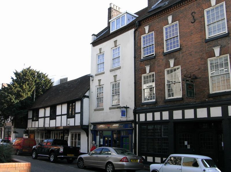
House, now restaurant and flat. c1760, possibly with C15
origins and with later additions and alterations including
attic c1960s and shop front c1996. Colour-washed render over
pinkish-orange brick in Flemish bond, with stone sills; plain
tile roof, left end stack with oversailing courses and pots.
Raised and coped gable end at left. 3 storeys plus attic, 2
first-floor windows. First- and second-floor windows have 6/6
sashes in near-flush frames, with flat arches, now rendered,
and keystones; all with sills. Dentil eaves cornice. Attic
dormer has plate-glass casement windows and flat roof.
Ground-floor shop front has glazed windows with mullions and
glazed entrance; 6-panel door at right.
INTERIOR: not inspected.
(Hughes, P. and Molyneux, N.: Worcester Streets: Friar Street:
Worcester: 1984-: PP. 13 - 14).
External links are from the relevant listing authority and, where applicable, Wikidata. Wikidata IDs may be related buildings as well as this specific building. If you want to add or update a link, you will need to do so by editing the Wikidata entry.


Other nearby listed buildings
