Approximate Location Map
Large Map »
Latitude: 52.1872 / 52°11'14"N
Longitude: -2.2351 / 2°14'6"W
OS Eastings: 384023
OS Northings: 254357
OS Grid: SO840543
Mapcode National: GBR 1G3.ZP1
Mapcode Global: VH92T.69R3
Plus Code: 9C4V5QP7+VX
Entry Name: 63, St Johns
Listing Date: 8 March 1974
Last Amended: 12 June 2001
Grade: II
Source: Historic England
Source ID: 1390117
English Heritage Legacy ID: 489087
ID on this website: 101390117
Location: St John's, Worcester, Worcestershire, WR2
County: Worcestershire
District: Worcester
Electoral Ward/Division: St John
Parish: Non Civil Parish
Built-Up Area: Worcester
Traditional County: Worcestershire
Lieutenancy Area (Ceremonial County): Worcestershire
Church of England Parish: St John in Bedwardine
Church of England Diocese: Worcester
Tagged with: Building
This list entry was subject to a Minor Amendment on 20/10/2016
SO8454SW
620-1/19/582
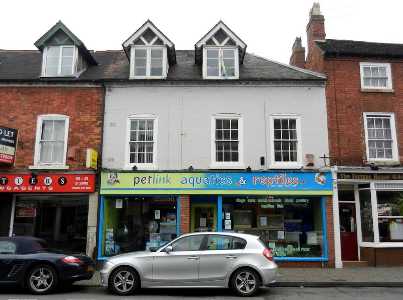
WORCESTER
ST JOHNS (South East side)
No.63
(Formerly listed as: No.63, ST JOHN'S, previously listed as ST JOHN'S (South East side) Nos.59-67 (Odd))
08/03/74
GV
II
Terraced house, now shop on ground-floor. Mid C18 with later additions and alterations. Painted brick with plain clay tile roof hipped to right, dentilled eaves. Stack to rear roof slope with oversailing detail and pots.Single-depth plan. Left-hand side of ground-floor was vehicular access to rear of properties, internal walls now all removed. 3 storeys. 3 (1:2) first-floor windows, all 6/6 in near-flush frames with sills and under cambered brick arches. Ground-floor is all mid-late C20. 2 large gabled dormers to left with paired 3-pane side-hung casements. Upper floors not inspected.
HISTORICAL NOTE: Through passage shown on 1886 OS map; planning application 14489 from 1959 shows passage still extant.
External links are from the relevant listing authority and, where applicable, Wikidata. Wikidata IDs may be related buildings as well as this specific building. If you want to add or update a link, you will need to do so by editing the Wikidata entry.


Other nearby listed buildings
