Approximate Location Map
Large Map »
Latitude: 52.4869 / 52°29'12"N
Longitude: -1.9123 / 1°54'44"W
OS Eastings: 406049
OS Northings: 287663
OS Grid: SP060876
Mapcode National: GBR 5X6.ND
Mapcode Global: VH9YW.SRWF
Plus Code: 9C4WF3PQ+P3
Entry Name: Bank
Listing Date: 29 April 2004
Grade: II
Source: Historic England
Source ID: 1391269
English Heritage Legacy ID: 494064
ID on this website: 101391269
Location: Brookfields, Birmingham, West Midlands, B1
County: Birmingham
Parish: Non Civil Parish
Built-Up Area: Birmingham
Traditional County: Warwickshire
Lieutenancy Area (Ceremonial County): West Midlands
Church of England Parish: Birmingham St Paul
Church of England Diocese: Birmingham
Tagged with: Building
BIRMINGHAM
997/0/10289 FREDERICK STREET
29-APR-04 35
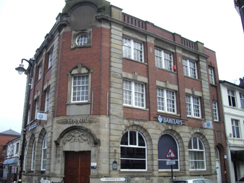
Bank
GV II
Bank. c.1905, with late C20 alterations. Red brick with ashlar stone dressings, and flat roof concealed by shallow parapet.
PLAN: Street corner site with elevations to Warstone Lane and Frederick Street.
EXTERIOR: Both street frontage of 3 bays , 3 storeys rising from a deep ashlar plinth. Ground floor of rusticated ashlar, with 3 wide semi-circular arch-headed openings, with deeply-chamfered reveals, and late C20 window frames. First and second floor bays defined by wide brick piers, and wide rusticated end pilasters. First floor windows are paired 6 over 9 pane sashes, beneath single keyed lintels, upper floor openings match those below. Moulded eaves cornice beneath a shallow parapet. End half-bay beyond rusticated pilaster, with panelled door with architrave surround beneath multi-pane overlight. Splayed corner entrance with moulded ashlar surround to doorway, below enriched tympanum with hood mould and label stops. Above, decorative panel with ' BANK' in relief lettering. Sash window with ashlar frame to first floor and occulus in square ashlar frame above. Cornice rises above parapet level. Warstone Lane elevation of 3 bays , detailed as Frederick Street frontage.
INTERIOR: Remodelled late C20, but with banking hall retaining moulded cornice work and central column.
HISTORY: Formerly the premises of The Birmingham District and Counties Bank, formed in 1889. This branch was opened on December 18th 1905.
Forms a group with the Rose Villa Tavern (q.v.) and the clock tower (q.v.)
A prominently- sited and boldly-detailed bank of 1905, displaying some of the architectural vocabulary of C20 industrial buildings of Birmingham's Jewellery Quarter, and helping to define the entrance to its core area.
External links are from the relevant listing authority and, where applicable, Wikidata. Wikidata IDs may be related buildings as well as this specific building. If you want to add or update a link, you will need to do so by editing the Wikidata entry.


Other nearby listed buildings
