Approximate Location Map
Large Map »
Latitude: 52.4856 / 52°29'8"N
Longitude: -1.9122 / 1°54'43"W
OS Eastings: 406058
OS Northings: 287528
OS Grid: SP060875
Mapcode National: GBR 5X6.PV
Mapcode Global: VH9YW.SSYC
Plus Code: 9C4WF3PQ+74
Entry Name: 48, Frederick Street
Listing Date: 29 April 2004
Grade: II
Source: Historic England
Source ID: 1391274
English Heritage Legacy ID: 494070
ID on this website: 101391274
Location: Brookfields, Birmingham, West Midlands, B1
County: Birmingham
Parish: Non Civil Parish
Built-Up Area: Birmingham
Traditional County: Warwickshire
Lieutenancy Area (Ceremonial County): West Midlands
Church of England Parish: Birmingham St Paul
Church of England Diocese: Birmingham
Tagged with: Building
BIRMINGHAM
997/0/10285
29-APR-04
FREDERICK STREET
48
GV
II
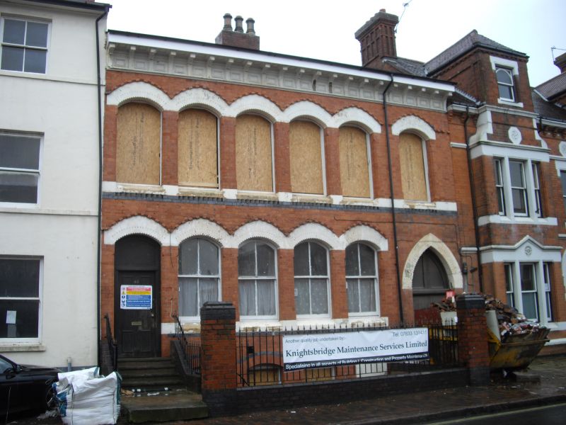
Manufactory. c. 1870 with minor late C20 alterations. Red brick with blue brick decoration and painted dressings. Slated roof with central, off-ridge brick stack.
PLAN: Double-pile frontage range with narrow parallel rear ranges. Venetian Gothic Style.
EXTERIOR: Near-symmetrical street frontage of 2 storeys above a basement. 6 bays, with doorways to bays 1 and 6, that to bay 1 the main entrance to the left with arch-headed overlight above the door. Wide goods doorway to right end bay with steep pointed arched head. 4 basement lights with shallow segmental arched heads and 2 over 2 pane sashes and serpentine blue brick band above window heads. Ground floor windows with 2 over 2 pane sash frames between narrow brick piers, with continuous painted cill and linked, painted brick arched heads
including that of main entrance. First floor windows with painted cill band above blue brick band with cogged brick below window openings. Heads to windows detailed as those below, above 2 over 2 pane sashes. Deep bracketed eaves cornice with acanthus leaf decoration between the brackets. Storeyed warehouse and workshop ranges to rear.
HISTORY: The site is shown on the Piggot- Smith map of 1855-61 as part of the garden of a large detached house to the north. The existing building is shown on the 1886 O.S.map, and the address is recorded in Kelly's Directory for 1886 as being occupied by jewellers and watch manufacturers.
Forms a group with No. 23 Frederick Street (q.v.) and No. 47 Frederick Street (q.v.)
A small purpose-built manufactory of c.1870 designed for multiple occupancy, well- preserved externally with detailing characteristic of the distinctive architecture of a specialist industrial quarter of Birmingham now recognised as being of international significance.
External links are from the relevant listing authority and, where applicable, Wikidata. Wikidata IDs may be related buildings as well as this specific building. If you want to add or update a link, you will need to do so by editing the Wikidata entry.


Other nearby listed buildings
