Approximate Location Map
Large Map »
Latitude: 50.9183 / 50°55'5"N
Longitude: 0.2109 / 0°12'39"E
OS Eastings: 555500
OS Northings: 115530
OS Grid: TQ555155
Mapcode National: GBR MSF.658
Mapcode Global: FRA C6BP.1Z9
Plus Code: 9F22W696+88
Entry Name: Old Bridge at Stream Mill
Listing Date: 26 September 2005
Grade: II
Source: Historic England
Source ID: 1391386
English Heritage Legacy ID: 494157
ID on this website: 101391386
Location: Hale Green, Wealden, East Sussex, BN8
County: East Sussex
District: Wealden
Civil Parish: Chiddingly
Traditional County: Sussex
Lieutenancy Area (Ceremonial County): East Sussex
Church of England Parish: Chiddingly
Church of England Diocese: Chichester
Tagged with: Bridge
CHIDDINGLY
981/0/10054 Old Bridge at Stream Mill
26-SEP-05
GV II
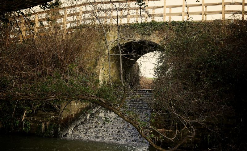
Single span bridge, probably of late C18 or early C19 date, with some later repair. Ashlar blocks, buttressed with brick repair and stone infill. Deck of slag.
DESCRIPTION: The keystone and arch is of ashlar. Parapet of wooden posts. Brick buttresses of probable early C19 type bonding. The deck of the bridge is of slag with stone protruding from the surface. Spillway on south side constructed of stone and brick. The bridge is closely associated with the operation of the nearby mill, and has the grooves of a sluice gate on the stone blocks of its north side, by which it regulated the water flow from the mill pond. The track over the bridge is the major bridle way through the village with links to the Weald and the Vanguard Way.
HISTORY: The bridge is closely associated with a mill which lies about 100m to its south east. On the north side of the bridge supports are the slots for sluice gates to control the flow of water from the mill pond, showing that the bridge dates at least from the time of the working mill. The mill, in turn, is associated with iron working on the site. It is first mentioned in the Doomsday Book, and iron working on the site dates from C15, when it was controlled by the Elphic family who were listed in documentary sources as 'iron masters'. In the mid 1500s the iron works passed to the French family, who were also 'iron masters', and is again mentioned in early C17 in the ownership of James Lullham. Canon boring took place in the Tudor period south of the bay near the mill. The mill was originally a hammer mill for the iron works, but by the early 1800s the iron working had ceased, and the mill became a corn mill.
SUMMARY OF IMPORTANCE: The bridge is significant as a well preserved late C18 - early C19 bridge, with an intact spillway, and as an integral part of the working of the nearby corn mill. Potential earlier fabric in the bridge gives it additional interest, as it ties the bridge to earlier uses of mill for iron working. The bridge also has group value with the nearby listed, C17 or earlier, Stream Farmhouse, and Barn, which has C16 and C17 elements.
SOURCES: H Cleere and D Crossley, The Iron Industry of the Weald (1985).
External links are from the relevant listing authority and, where applicable, Wikidata. Wikidata IDs may be related buildings as well as this specific building. If you want to add or update a link, you will need to do so by editing the Wikidata entry.


Other nearby listed buildings
