Approximate Location Map
Large Map »
Latitude: 51.5279 / 51°31'40"N
Longitude: -0.0893 / 0°5'21"W
OS Eastings: 532642
OS Northings: 182724
OS Grid: TQ326827
Mapcode National: GBR S6.3G
Mapcode Global: VHGQT.DVNM
Plus Code: 9C3XGWH6+47
Entry Name: Gunpost Near the Junction with City Road
Listing Date: 13 July 2006
Grade: II
Source: Historic England
Source ID: 1391700
English Heritage Legacy ID: 495971
ID on this website: 101391700
Location: Hoxton, Hackney, London, EC1V
County: London
District: Hackney
Electoral Ward/Division: Hoxton West
Parish: Non Civil Parish
Built-Up Area: Hackney
Traditional County: Middlesex
Lieutenancy Area (Ceremonial County): Greater London
Church of England Parish: Holy Trinity Hoxton
Church of England Diocese: London
Tagged with: Architectural structure
735/0/10206 BRITANNIA WALK
13-JUL-06 (West side)
Gunpost near the junction with City Road
II
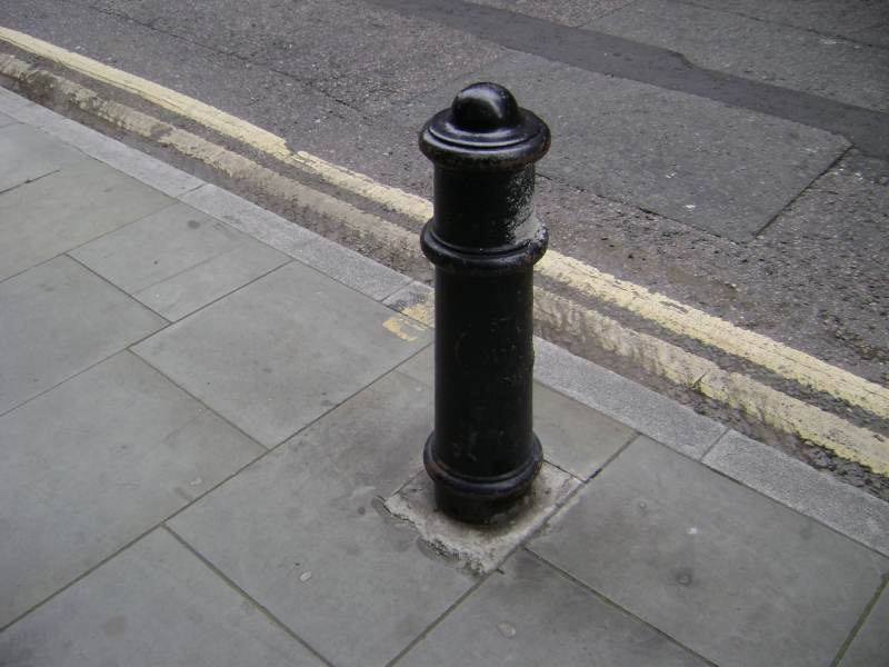
Cast iron gun-post, early-mid C19, of a typical design in its original location.
Inscribed on the plinth is: "ST L / MIDDLESEX / No. 109". It is likely that the illegible character was an S, making the first line "St L S", the shorthand for St Leonard's Shoreditch used on several of the other gun-posts in the area. This gun-post marks the boundary of the parish of St Leonard's Shoreditch, a grade I listed church of 1736 by George Dance the Elder.
HISTORY: Following the end of the Napoleonic Wars many cannons were used as bollards, mostly appearing on the streets of London. These cannon-bollards inspired the design of this gun-post, and the others in the area which mark the boundary of the parish of St Leonard's Shoreditch. Parish boundaries have now been superseded but from the medieval period until the C20 they were the principal administrative units of government, used, for example, for the distribution of social welfare and in official records.
SUMMARY OF IMPORTANCE: This cast iron gun-post dates from the early-mid C19 and marks the boundaries of the parish of St Leonard's Shoreditch. Gun-post boundary markers are an interesting reminder of this historical division of land and for this the gun-post near the junction of City Road and Britannia Walk, which survives in its original location, is of special historic interest. This gun-post is also of architectural special interest as a surviving fragment of the early-mid C19 streetscape, in a design inspired by the cannons used in the the Napoleonic Wars.
External links are from the relevant listing authority and, where applicable, Wikidata. Wikidata IDs may be related buildings as well as this specific building. If you want to add or update a link, you will need to do so by editing the Wikidata entry.


Other nearby listed buildings
