Approximate Location Map
Large Map »
Latitude: 52.9552 / 52°57'18"N
Longitude: -2.0095 / 2°0'34"W
OS Eastings: 399461
OS Northings: 339758
OS Grid: SJ994397
Mapcode National: GBR 26G.NSY
Mapcode Global: WHBD3.3ZDC
Plus Code: 9C4VXX4R+36
Entry Name: Milepost at SJ9945039761 Approximately 140M East of Totmonslow Farm
Listing Date: 18 June 2007
Grade: II
Source: Historic England
Source ID: 1392047
English Heritage Legacy ID: 502765
ID on this website: 101392047
Location: Totmonslow, Staffordshire Moorlands, Staffordshire, ST10
County: Staffordshire
District: Staffordshire Moorlands
Civil Parish: Draycott in the Moors
Traditional County: Staffordshire
Lieutenancy Area (Ceremonial County): Staffordshire
Church of England Parish: Draycott-le-Moors St Margaret
Church of England Diocese: Lichfield
Tagged with: Milestone
DRAYCOTT IN THE MOORS
1663/0/10010 TOTMONSLOW
18-JUN-07 Milepost at SJ9945039761 approximately
140m east of Totmonslow Farm
II
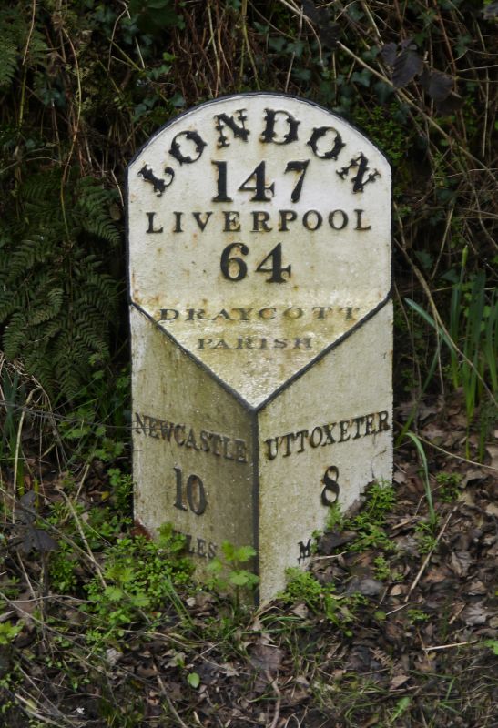
Early C19 milepost of painted cast iron; triangular in section with inclined head and segmental-arched, raised back plate. Relief lettering inscription; right face: UTTOXETER 8 MILES; left face: NEWCASTLE 10 MILES; head: DRAYCOTT PARISH; back plate: LONDON 147 / LIVERPOOL 64.
HISTORY: The milepost was erected by the Uttoxeter to Blythe Marsh Turnpike Trust. It was cast in Burton upon Trent in 1828.
Summary of Importance: Milestones are of national importance as they are some of the few physical remains of national and local historic road use. The mileposts on this route reflect the standardisation of roads and the introduction of turnpikes to facilitate the transport needs of the increasingly industrial landscape of C18 Staffordshire. This is one of a number of C19 cast iron mileposts to mark the turnpike between Uttoxeter and Blythe Marsh. The post remains intact and in its original location. It also has group value with other listed mileposts on this route.
SJ9946139757
External links are from the relevant listing authority and, where applicable, Wikidata. Wikidata IDs may be related buildings as well as this specific building. If you want to add or update a link, you will need to do so by editing the Wikidata entry.


Other nearby listed buildings
