Approximate Location Map
Large Map »
Latitude: 51.526 / 51°31'33"N
Longitude: -0.0478 / 0°2'52"W
OS Eastings: 535524
OS Northings: 182590
OS Grid: TQ355825
Mapcode National: GBR J8.JML
Mapcode Global: VHGQV.4X22
Plus Code: 9C3XGXG2+9V
Entry Name: Eastern Counties Railway London Viaduct
Listing Date: 4 September 2007
Grade: II
Source: Historic England
Source ID: 1392242
English Heritage Legacy ID: 501259
ID on this website: 101392242
Location: Globe Town, Tower Hamlets, London, E1
County: London
District: Tower Hamlets
Electoral Ward/Division: Bethnal Green
Parish: Non Civil Parish
Built-Up Area: Tower Hamlets
Traditional County: Middlesex
Lieutenancy Area (Ceremonial County): Greater London
Church of England Parish: St John on Bethnal Green
Church of England Diocese: London
Tagged with: Viaduct Railway viaduct
788/0/10171 BANCROFT ROAD
04-SEP-07 Eastern Counties Railway London Viaduct
II
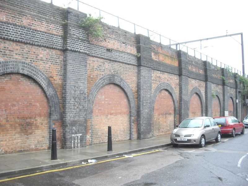
Former Eastern Counties Railway Viaduct to north of Bancroft Road, including road bridge. 1839-40 by John Braithwaite, engineer, for the Eastern Counties Railway. Yellow stock brick, sandstone dressings.
EXTERIOR: the remains of the original Eastern Counties Railway viaduct lie on the south side of this stretch of the approaches to Liverpool Street. They comprise a row of ten arches, part-concealed by buildings in front and later accretions. Each shallow elliptical arch has an opening (now in-filled) with a surround of seven courses of brick headers, above which is a string course of sandstone at track level and a parapet of brick, with sandstone coping. The arches are continued to the north, the result of the track widening of c.1891. The second wide arch to the left of the bridge, which has been largely reconstructed, was the former location of the former Globe Road and Devonshire Street station (opened 1884, closed 1916). To the left of the bridge are two blind arches set between pylon-formed buttresses, their lower courses hidden by later blue brick bases. The skew bridge is a very shallow elliptical opening, with radiating voussoirs of sandstone set above an impost band of sandstone. To the right of the bridge, the viaduct gives way to an embankment.
HISTORY: the Eastern Counties Railway was established by an Act of 1836 and was the first to link London with East Anglia by rail. It initially connected Romford with Mile End, in June 1839: the line was continued westwards to Shoreditch in June 1840 (renamed Bishopsgate in 1845). The engineer was John Braithwaite (1797-1870), a noted mechanical engineer who was also given responsibility for the construction of the line into London. The viaduct is among the earliest, and longest, examples of a first-generation railway structure to survive in London. The viaduct was widened to the north later in the 19th century: it is the 1839-40 parts that are of special interest.
SOURCES: J.E. Connor, 'Liverpool Street to Ilford' (Midhurst 1999); G. Goslin, 'John Braithwaite and the Bishopsgate Viaduct' (London Railway Heritage Society 2002).
External links are from the relevant listing authority and, where applicable, Wikidata. Wikidata IDs may be related buildings as well as this specific building. If you want to add or update a link, you will need to do so by editing the Wikidata entry.


Other nearby listed buildings
