Approximate Location Map
Large Map »
Latitude: 52.9888 / 52°59'19"N
Longitude: -1.9871 / 1°59'13"W
OS Eastings: 400960
OS Northings: 343498
OS Grid: SK009434
Mapcode National: GBR 263.NFC
Mapcode Global: WHBD3.F4ZJ
Plus Code: 9C4WX2Q7+G4
Entry Name: Milestone near Junction of Leek Road and Queen Street
Listing Date: 30 April 2008
Grade: II
Source: Historic England
Source ID: 1392590
English Heritage Legacy ID: 503397
ID on this website: 101392590
Location: Cheadle, Staffordshire Moorlands, Staffordshire, ST10
County: Staffordshire
District: Staffordshire Moorlands
Civil Parish: Cheadle
Built-Up Area: Cheadle
Traditional County: Staffordshire
Lieutenancy Area (Ceremonial County): Staffordshire
Church of England Parish: Cheadle St Giles
Church of England Diocese: Lichfield
Tagged with: Milestone
1663/0/10012
CHEADLE
LEEK ROAD (A522)
Milestone near Junction of Leek Road and Queen Street
30-APR-08
II
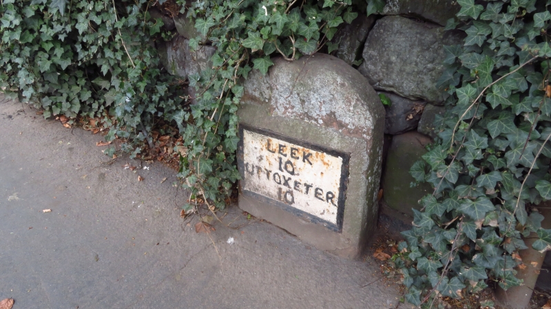
A mid C18 milestone with early C19 cast iron name plate attached to its front. The dressed stone has a rounded top and the plate is inscribed LEEK 10 UTTOXETER 10. The lettering and plate border are picked out in black, whilst the remainder of the plate is painted white.
HISTORY: The milestone is believed to have been erected during the 1760s and represents one of a series denoting the turnpike route from Wetley Rocks via Cheadle and Tean to Rochester. The plate attached to the front of the stone is believed to have been added in the 1820s and by 1840 the stone formed part of the consolidated Cheadle turnpike.
REASONS FOR DESIGNATION DECISION
Milestone near junction of Leek Road and Queen Street, Cheadle is designated at Grade II, for the following principal reasons:
* A well preserved example of a mid C18 milestone with early C19 plate, showing the expansion of the road network and the impact of the 1773 general Turnpike Act, which made recording the mileage compulsory
* This is one of a number of C18 milestones with early C19 plates that mark the turnpike between Wetley Rocks and Cheadle
* It has group value with other milestones on this route
* A well preserved example of a mid-C18 milestone with early C19 plate, showing the expansion of the road network and the impact of the 1773 general Turnpike Act, which made recording the mileage compulsory
* This is one of a number of C18 milestones with early-C19 plates that mark the turnpike between Wetley Rocks and Cheadle
* It has group value with other milestones on this route
External links are from the relevant listing authority and, where applicable, Wikidata. Wikidata IDs may be related buildings as well as this specific building. If you want to add or update a link, you will need to do so by editing the Wikidata entry.


Other nearby listed buildings
