Approximate Location Map
Large Map »
Latitude: 53.078 / 53°4'40"N
Longitude: -2.1189 / 2°7'8"W
OS Eastings: 392129
OS Northings: 353425
OS Grid: SJ921534
Mapcode National: GBR 13M.52C
Mapcode Global: WHBCG.FW6Q
Plus Code: 9C5V3VHJ+5C
Entry Name: Milepost Outside 'Kings Croft', West of Endon Village
Listing Date: 29 July 2008
Grade: II
Source: Historic England
Source ID: 1392685
English Heritage Legacy ID: 503330
ID on this website: 101392685
Location: Endon, Staffordshire Moorlands, Staffordshire, ST9
County: Staffordshire
District: Staffordshire Moorlands
Civil Parish: Endon and Stanley
Built-Up Area: Stoke-on-Trent
Traditional County: Staffordshire
Lieutenancy Area (Ceremonial County): Staffordshire
Church of England Parish: Endon St Luke
Church of England Diocese: Lichfield
Tagged with: Milestone
ENDON AND STANLEY
1798/0/10027 CLAY LAKE (B5051)
29-JUL-08 Milepost outside 'Kings Croft', west
of Endon Village
GV II
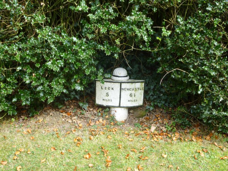
Milepost. Dated 1879 by Hales & Co. of Cobridge, Stoke-on-Trent. Cast iron. A convex-shaped rectangular display set on a circular shaft which has a domed head. The display is divided down the centre and inscribed on the left side: `LEEK / 5 / MILES', and on the right: `NEWCASTLE / 6½ / MILES'.
HISTORY: The road between Newcastle-under-Lyme and Leek, which ran via Burslem, was turnpiked in 1765. A further turnpike road (now the A53), built under an Act of 1840, enters Endon from the south west and joined the former to the north east of Endon. The mileposts on the Newcastle-Leek road which dated from the early C19 were replaced in 1879 following the introduction of a countywide replacement scheme. On the First Edition Ordnance Survey map (1879) the distances given relate to the earlier milepost; those on later editions give the distances to Burslem and Leek rather than Newcastle as inscribed on the milepost itself. This is true for all the markers on this route.
SOURCES
Ordnance Survey maps (1879, 1899, 1925)
REASON FOR DESIGNATION DECISION:
This milepost on the B5051, to the west of Endon, merits designation at Grade II for the following principal reasons:
* It is a legible, intact example of a late-C19 milepost, reflecting the expansion of the road network and the impact of the 1773 general Turnpike Act, which made recording mileage compulsory.
* It is comparable to other listed cast iron mileposts on the Newcastle to Leek turnpike road.
SJ9212953425
This milepost on the B5051, to the west of Endon, is designated at Grade II for the following principal reasons:
* It is a legible, intact example of a late-C19 milepost, reflecting the expansion of the road network and the impact of the 1773 general Turnpike Act, which made recording mileage compulsory.
* It is comparable to other listed cast iron mileposts on the Newcastle to Leek turnpike road.
External links are from the relevant listing authority and, where applicable, Wikidata. Wikidata IDs may be related buildings as well as this specific building. If you want to add or update a link, you will need to do so by editing the Wikidata entry.


Other nearby listed buildings
