Approximate Location Map
Large Map »
Latitude: 51.4585 / 51°27'30"N
Longitude: -2.6014 / 2°36'5"W
OS Eastings: 358312
OS Northings: 173446
OS Grid: ST583734
Mapcode National: GBR C6J.M1
Mapcode Global: VH88M.VLLT
Plus Code: 9C3VF95X+9C
Entry Name: Ivy Gate, North East of Royal Fort House
Listing Date: 12 August 2008
Grade: II
Source: Historic England
Source ID: 1392702
English Heritage Legacy ID: 505442
ID on this website: 101392702
Location: Tyndall's Park, Bristol, BS8
County: City of Bristol
Electoral Ward/Division: Central
Parish: Non Civil Parish
Built-Up Area: Bristol
Traditional County: Gloucestershire
Lieutenancy Area (Ceremonial County): Bristol
Church of England Parish: Clifton, St Paul
Church of England Diocese: Bristol
Tagged with: Architectural structure
BRISTOL
901-1/0/10189 TYNDALL AVENUE
12-AUG-08 (South side)
IVY GATE, NE OF ROYAL FORT HOUSE
II
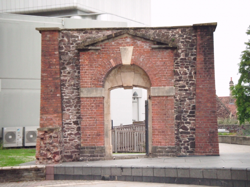
Monumental gate, of mid-C18 date, constructed of red brick laid to English Garden Wall bond, coursed stone rubble and ashlar detail, on a coursed rubble plinth. The gate is flanked by massive brick piers with clear entasis and topped with projecting concrete coping supported on moulded brick corbels. The north-east elevation is of brick and has an ashlar triple keystone to the round-arched opening. The south-west elevation is more decorative with central brick projection against the stone rubble face. This is surmounted by an open pediment. Beneath this is the round-arched opening with large single ashlar keystone and impost blocks. Within the arch, to both elevations, is an inner gate of ashlar with quintuple-keystone, the middle three sections of which are sequentially dropped.
The gate stands on a slight slope and stone steps to the south-west elevation accommodate this.
HISTORY: Ivy Gate is depicted on Roque's map of 1742 and provided the entrance to a garden which formed part of the holdings associated with Cromwell House. The house (demolished in the late-C19) was one of five built on this part of St Michael's Hill in the latter half of the C17 and stood approximately 40m to the west of the gate.
SOURCES: Roger H Leech, The St Michael's Hill Precinct of the University of Bristol. (2000) Bristol Record Society Vol. 52. 45, 57
Andrew Foyle, Bristol. (2004) Pevsner Architectural Guide.
REASONS FOR DESIGNATION DECISION: Ivy Gate is designated at Grade II for the following principal reasons:
* It is an interesting and important survival of a mid-C18 garden structure which remains intact.
* It has distinct architectural presence.
* The quality and combination of materials used, the gate's design, as well as its monumental scale, convey the wealth and ambition of the residents of St Michael's Hill during the C18.
* It has group value with other listed buildings further down the hill, such as Royal Fort House, which relate to the C17 and C18 suburban development of the area.
* It makes a positive contribution to the overall character of this part of the university campus.
Ivy Gate has been designated at Grade II for the following principal reasons:
* It is an interesting and important survival of a mid-C18 garden structure which remains intact.
* It has distinct architectural presence.
* The quality and combination of materials used, the gate's design, as well as its monumental scale, convey the wealth and ambition of the residents of St Michael's Hill during the C18.
* It has group value with other listed buildings further down the hill, such as Royal Fort House, which relate to the C17 and C18 suburban development of the area.
* It makes a positive contribution to the overall character of this part of the university campus.
External links are from the relevant listing authority and, where applicable, Wikidata. Wikidata IDs may be related buildings as well as this specific building. If you want to add or update a link, you will need to do so by editing the Wikidata entry.


Other nearby listed buildings
