Approximate Location Map
Large Map »
Latitude: 51.1117 / 51°6'42"N
Longitude: 1.3196 / 1°19'10"E
OS Eastings: 632453
OS Northings: 139953
OS Grid: TR324399
Mapcode National: GBR X35.BFC
Mapcode Global: VHLHJ.TBH3
Plus Code: 9F334869+MV
Entry Name: Admiralty Pier and Associated Structures, Including Admiralty Pier Lighthouse
Listing Date: 16 December 2009
Grade: II
Source: Historic England
Source ID: 1393608
English Heritage Legacy ID: 507158
ID on this website: 101393608
Location: Dover, Kent, CT17
County: Kent
District: Dover
Civil Parish: Dover
Built-Up Area: Dover
Traditional County: Kent
Lieutenancy Area (Ceremonial County): Kent
Tagged with: Architectural structure
685/0/10035
DOVER
Admiralty Pier and associated structures, including Admiralty Pier lighthouse
16-DEC-09
GV
II
Harbour Pier, including lighthouse. The landward half was constructed between 1847 and 1872 in three successive contracts, designed by James Walker and his pupil partner Alfred Burges, completed after his death by Sir John Robinson McClean FRS. Sir John Hawkshaw, engineer to the Harbour Commissioners also had a design input. The contractors were Henry Lee and Sons. The seaward half is an extension of 1898-1909 designed to be part of the Admiralty Harbour of Refuge by the firm of Coode, Son and Mathews. The separately scheduled gun turret situated at the end of the 1872 part is not included in the listing. The attached Spur Pier and Cruise Terminal 2 are not of special interest.
MATERIALS: The first part of the pier to be built was entirely constructed of tooled granite ashlar but later pre-cast concrete blocks were used below the water. The later pier extension is constructed of concrete blocks of 26 to 42 tons each, faced above sea level with tooled granite ashlar. The lighthouse is constructed of cast iron.
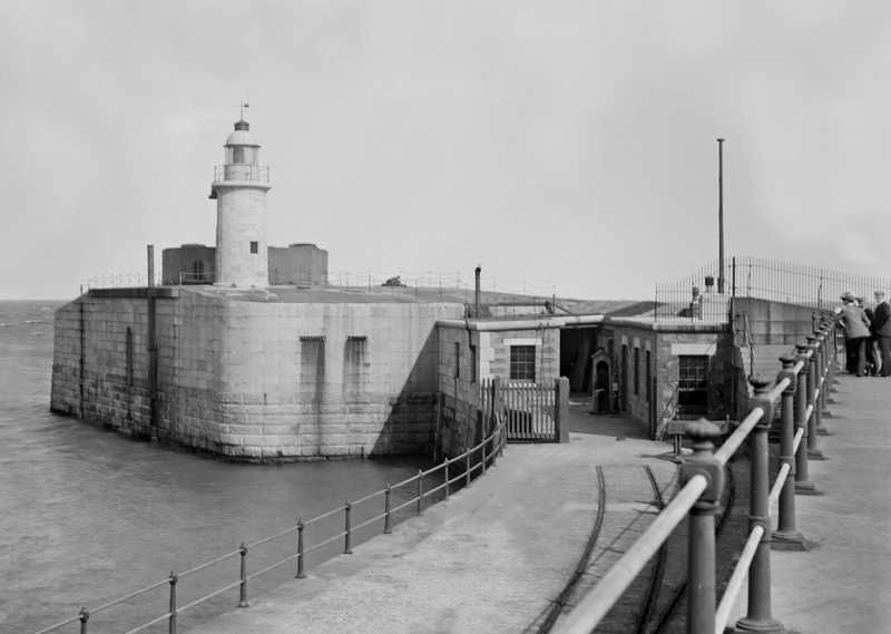
PLAN: The earlier landward part of 2,100 feet is aligned northwest to southeast and has the scheduled gun turret at its southeastern end. The later section of 2000 feet is aligned due east and has a lighthouse at the eastern end.
DESCRIPTION: Granite is visible along the entire length of the southwestern seaward side but the northeastern harbour side was extended outwards in 1909 in order to build the Marine Railway station and later in the C20 to build a cruise terminal so that the original fabric on this side is visible only towards the seaward end. There is a raised walkway on the south-western side with flights of stone steps and C19 metal handrails.
About halfway along, where the 1872 pier terminated, is the 1882 circular gun turret which is protected by scheduling. This is faced in ashlar over brick but has a smaller circular cast iron projection with brick and stone parapet in the centre. This is 11 metres in diameter and 3 metres high. The twin Armstrong muzzle-loading 81 ton guns survive internally but the boilers and steam engine are no longer present. The guns are now embedded in a later wooden deck. In the chamber under the turret, the turret's iron framework and its traversing ring survive. The six inch shell lifts also survive.
The Admiralty Pier extension retains a number of cast iron cleats on the northeast side and near the end of the pier extension on the south-west side is barrack accommodation for gunners. The pier terminates in a circular end, on which the Admiralty Pier Lighthouse is built.
The lighthouse has a circular stone base upon which is a central cylindrical iron column containing a staircase, surrounded by six iron supports tapering towards the top with cross-shaped iron ties. At the top is a circular room with small fixed windows, a projecting walkway supported on brackets and a large round-headed lantern.
HISTORY: Admiralty Pier was begun in 1847 to form the western arm of Dover Harbour. The idea was to form a large national harbour of which Admiralty Pier was deigned to be only one part, the direct outcome of a third Royal Commission of 1845. The other parts of the scheme were never executed.
Admiralty Pier was designed by the distinguished marine engineer James Walker (1781-1862) and his pupil partner Alfred Burges (1797-1886) and completed after his death by Sir John Robinson McClean FRS (1813-1873). Sir John Hawkshaw (1811-1891), engineer to the Harbour Commissioners, also had a design input. The contractors were Henry Lee and Sons and the work was executed in stages under three successive contracts. By 1850 the pier had solved Dover Harbour's ancient problem of shingle drifting eastwards. In 1861, the South Eastern Railway extended their line onto the still unfinished Admiralty Pier for the interchange with continental ferries and from 1864 the London, Chatham and Dover line also ran onto the pier. There were two parallel railway tracks, belonging to two railway companies before their merger in 1899. By 1872 the structure was 2,100 feet long.
In the beginning granite was used but later on concrete blocks were used below the water. The Admiralty Pier was the first marine structure in the country in which pre-cast concrete blocks were used. In the mid-C19 most breakwaters were constructed using the "pierre perdu" method (stones thrown in at random) but this was a notable example of a solid masonry structure with straight sides. It included a lighthouse at the southeast end, and in 1882 a circular gun turret was constructed at this end containing twin Armstrong muzzle-loading 81 ton guns. The guns, originally steam-driven, were the only steam powered guns ever possessed by the coastal artillery in Britain. By the end of the 1890s the advent of breach loading made these guns obsolete.
In 1909 emplacements for 2 inch breach loaders were constructed on either side with accommodation for gun detachments. In 1940-1 a Bofors light anti-aircraft gun was mounted on it. The ordnance was removed in 1944 and the store and accommodation buildings demolished in 1958.
Between 1898-1909 Admiralty Pier was extended by a further 2000 feet as the western arm of Admiralty Harbour, which also included the Eastern Arm and the Southern Breakwater. The Admiralty Harbour was designed to provide a protected anchorage for the naval fleet and increase the protection of the already existing commercial harbour. Admiralty Harbour was constructed by the firm of Coode, Son and Mathews, the successor firm to Sir John Coode, probably the greatest harbour engineer of the C19. The lighthouse, shown as disused on the 1907 map, was moved to the extreme end of the pier extension where it is first shown on the 1937 Ordnance Survey sheet. In 1909 the pier structure was widened at the landward end in order to build Dover Marine Railway Station for the South Eastern and Chatham Railway Co. Guns were provided in concrete emplacements, with searchlights in boom defences to defend the entrance into the harbour between the Admiralty Pier and the Southern Breakwater. During the First World War, Dover and its harbour formed one of the most important military centres in Britain. Troops and equipment were sent from Dover Harbour to the trenches, and the harbour was a haven for warships and submarines. Dover Harbour operated the Dover Patrol, consisting of about forty warships, motor boats and fishing vessels which kept control of the English Channel. In 1926 it was decided that the Admiralty Harbour had limited military use and it was decided to hand it, including the Admiralty Pier, to the Dover Harbour Board for administration as a commercial undertaking.
The widened landward end of the pier for the Marine Railway Station is first shown on the 1937 Ordnance Survey map. During the Second World War, Dover Harbour was particularly important in the Dunkirk evacuation as 200,000 men were returned from Dunkirk to Dover in eight days. After 1945, the navy withdrew. More recently part of the Admiralty Pier extension has been widened in order to build a Cruise terminal.
SOURCES:
"The Builder", September 18 (1847), 441-443
"The Royal Engineers Journal", September 1 (1903), 198-9
Oxford Dictionary of National Biography, articles on James Walker and Sir John Hawkshaw
A Hasenson, The History of Dover Harbour (1980), Passim.
O S Nock, Railway Architecture (1981), 69-70
Col. B E Arnold, Conflict across the Strait (1982), Passim.
R A Otter, Civil Engineering Heritage. Southern England (1994), 247-249
A Saunders and V Smith, Kent's Defence Heritage. Vol. 1 (2001), entries on Dover Harbour Breakwater Defence (KD 107) and Dover Turret (KD 108)
English Heritage unpublished report "Dover Harbour - Notes on Historical and Engineering interest", September 2008
Marine Archeology Ltd. Unpublished report "Dover Terminal 2. Historic Environment Baseline Report". October 2008.
A Saint, Architect and Engineer (2008), 210.
http://www.dover-kent.co.uk/transport/admiralty-pier.htm Accessed 21/07/2009.
http://www.dover-kent.co.uk/defence/admiralty-pier-turret.htm Accessed 22/07/09.
REASONS FOR DESIGNATION:
Admiralty Pier and associated structures, including Admiralty Lighthouse, are designated at Grade II for the following principal reasons:
* Historic interest: the earliest part of the pier, built between 1847 and 1872, is the only part of Walker and Burges' mid C19 project for an artificial harbour for Dover to be constructed.
* Constructional interest: the pier is unusual for its date because it is constructed of masonry rather than the prevalent "pierre perdu" system and has technological innovation as the first marine structure in which pre-cast concrete blocks were used.
* Engineering interest: the Admiralty Pier extension, added between 1898-1909, was designed as the western breakwater to Admiralty Harbour, a huge and impressive engineering project to form a harbour of refuge for the British fleet and the first artificial harbour in the country to be built in the C20.
* Group value: the Admiralty Pier extension is an integral part of the Admiralty Harbour, which also includes the Eastern Arm and the Southern Breakwater and groups with two other listed harbour structures.
* Historic interest: the pier had an important wartime role during both world wars; in the First World War as a haven for battleships and submarines of the Dover Patrol protecting the English Channel, and in the Second World War for its part in the Dunkirk evacuation.
Admiralty Pier and associated structures, including Admiralty Lighthouse are designated at Grade II for the following principal reasons:
* Historic interest: the earliest part, built between 1847 and 1872, is the only part of Walker and Burges' mid C19 project for an artificial harbour for Dover to be constructed.
* Constructional interest: the pier is unusual for its date because it is a masonry structure rather than the "pierre perdu" system of stones thrown at random, prevalent for the construction of breakwaters at this time.
* Technological innovation: the pier was the first marine structure in the country in which pre-cast concrete blocks were used.
* Engineering interest: the Admiralty Pier extension, added between 1898-1909, was designed as the western breakwater to a vast artificial harbour called Admiralty Harbour, designed by the distinguished firm of Coode, Son and Mathews, to provide a harbour of refuge for the British fleet,a huge and impressive engineering project and the first artificial harbour in England to be built in the C20.
* Intactness: the structure of Admiralty Pier survives little altered. Although part of the harbour side is masked by reclaimed land, the original fabric is likely to remain behind.
* Group value: the pier forms a group with the former Dover Marine Railway Station, including its walkway, which adjoins Admiralty Pier, and Lord Warden House, both listed Grade II. Additionally, the pier is an integral part of the Admiralty Harbour, the other two parts of which, the Eastern Arm and the Southern Breakwater, are also currently being assessed.
* Historic interest: the pier had an important wartime role during both world wars; in the First World War as a haven for battleships and submarines protecting the Channel, and in the Second World War for its major part in the Dunkirk evacuation.
External links are from the relevant listing authority and, where applicable, Wikidata. Wikidata IDs may be related buildings as well as this specific building. If you want to add or update a link, you will need to do so by editing the Wikidata entry.


Other nearby listed buildings
