Approximate Location Map
Large Map »
Latitude: 51.3835 / 51°23'0"N
Longitude: -2.3572 / 2°21'25"W
OS Eastings: 375238
OS Northings: 164997
OS Grid: ST752649
Mapcode National: GBR 0QH.BVC
Mapcode Global: VH96M.3H68
Plus Code: 9C3V9JMV+94
Entry Name: 6, Argyle Street
Listing Date: 12 June 1950
Last Amended: 15 October 2010
Grade: II
Source: Historic England
Source ID: 1394147
English Heritage Legacy ID: 509542
ID on this website: 101394147
Location: Bath, Bath and North East Somerset, Somerset, BA2
County: Bath and North East Somerset
Parish: Non Civil Parish
Built-Up Area: Bath
Traditional County: Somerset
Lieutenancy Area (Ceremonial County): Somerset
Tagged with: Building
ARGYLE STREET
(North side)
No. 6 (Formerly Listed as:
ARGYLE STREET (North side)
Nos. 1-7 (Consec))
12/06/50
GV II
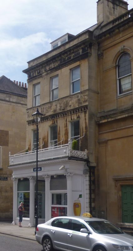
Shop with accommodation over. c1789 with only C19 alterations. By Thomas Baldwin.
MATERIALS: Bath limestone ashlar with Welsh slate roof.
PLAN: Double depth plan with later full height rear wing.
EXTERIOR: Three storeys, attic and basement storey, three windows wide. No. 6 matches No. 7 on either side of the slightly recessed Goodridge front of the Argyle Congregational Chapel, making a balanced terrace of nine bays, three:three:three, of similar character to the original wholly Baldwin design, except that the centre was then further recessed. Good mid C19 double fronted shop front, four fluted Corinthian columns support a deep entablature with iron balconette over. Plate glass windows, recessed central entrance. Windows above are all late C19 plain sashes. Pompeian scroll band at second floor level and sill band above, remains of painted inscription below second floor windows. Cornice, parapet, mansard roof with double flat topped dormer, ashlar stack with pots. Return elevation to Grove Street, ashlar, platband at first floor level, no windows. Rear elevation has full height late C19 wing in ashlar with plain sashes. Main elevation, rubble, one window to each floor and one dormer, all plain sashes.
INTERIOR: Not inspected. Ground floor much altered.
HISTORY: Argyle Street, first Argyle Buildings, was the extension of the line of Adam's Pulteney Bridge (qv) into Sir William Pulteney's Bathwick estate. The estate passed to his daughter Henrietta Laura in 1792, but building work had already begun on Laura Place in 1788. This terrace, with its southern opposite number, forms a monumental extension northwards from Robert Adam¿s Pulteney Bridge.
Listing NGR: ST7523864997
External links are from the relevant listing authority and, where applicable, Wikidata. Wikidata IDs may be related buildings as well as this specific building. If you want to add or update a link, you will need to do so by editing the Wikidata entry.


Other nearby listed buildings
