Approximate Location Map
Large Map »
Latitude: 51.3848 / 51°23'5"N
Longitude: -2.3748 / 2°22'29"W
OS Eastings: 374013
OS Northings: 165147
OS Grid: ST740651
Mapcode National: GBR 0QH.0FV
Mapcode Global: VH96L.SGD9
Plus Code: 9C3V9JMG+W3
Entry Name: Sterling House
Listing Date: 5 August 1975
Last Amended: 15 October 2010
Grade: II
Source: Historic England
Source ID: 1395449
English Heritage Legacy ID: 510852
ID on this website: 101395449
Location: Westmoreland, Bath and North East Somerset, Somerset, BA1
County: Bath and North East Somerset
Parish: Non Civil Parish
Built-Up Area: Bath
Traditional County: Somerset
Lieutenancy Area (Ceremonial County): Somerset
Church of England Parish: Bath St Michael Without
Church of England Diocese: Bath and Wells
Tagged with: House
UPPER BRISTOL ROAD
656-1/29/1729 (South side)
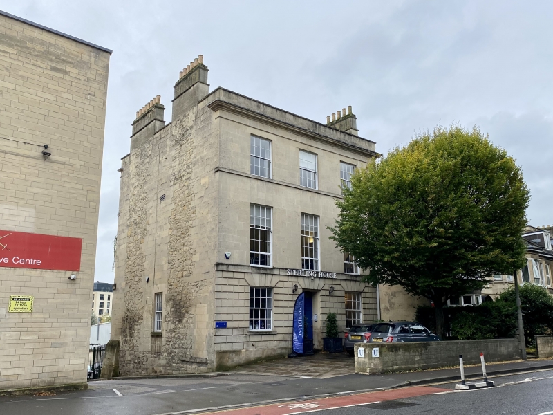
Sterling House
(formerly Albion House)
05/08/75
GV II
House, now offices, on sloping site. c1790.
MATERIALS: Limestone ashlar, double-pitched roof (unseen) with moulded stacks to returns.
PLAN: Double depth plan.
EXTERIOR: Three storeys and basement, symmetrical three-window front. Building encircled by level coped parapet, cornice, lintel frieze and second floor sill band slightly returned, ground floor platband and chamfered rustication with radial voussoirs not returned, eight/eight-pane horned sash windows, lowered first floor sills with extra row of panes above platband, set back door to centre. Left return, rubblestone to stacks, has small horned six/six-pane sash window to centre of ground floor. Right return partially enveloped by late (not listed) C19 house. Rear elevation has a cast iron balcony to right hand ground floor window with strigillated decoration.
INTERIOR: Not inspected; believed to retain some plasterwork.
HISTORY: A house is shown in this position on Harcourt Masters's 1793 map of Bath, then right on the edge of town.
Listing NGR: ST7401365147
External links are from the relevant listing authority and, where applicable, Wikidata. Wikidata IDs may be related buildings as well as this specific building. If you want to add or update a link, you will need to do so by editing the Wikidata entry.


Other nearby listed buildings
