Approximate Location Map
Large Map »
Latitude: 51.3904 / 51°23'25"N
Longitude: -2.4084 / 2°24'30"W
OS Eastings: 371680
OS Northings: 165783
OS Grid: ST716657
Mapcode National: GBR JZ.RNWT
Mapcode Global: VH96L.69MZ
Plus Code: 9C3V9HRR+5J
Entry Name: New Bridge or Newton Bridge
Listing Date: 11 August 1972
Last Amended: 15 October 2010
Grade: II*
Source: Historic England
Source ID: 1395726
English Heritage Legacy ID: 511136
Also known as: Newton Bridge
Newbridge
ID on this website: 101395726
Location: Newbridge, Bath and North East Somerset, Somerset, BA1
County: Bath and North East Somerset
Parish: Non Civil Parish
Built-Up Area: Bath
Traditional County: Somerset
Lieutenancy Area (Ceremonial County): Somerset
Tagged with: Road bridge
NEWBRIDGE ROAD WEST AND BRISTOL ROAD
New Bridge or Newton Bridge
11/08/72
II*
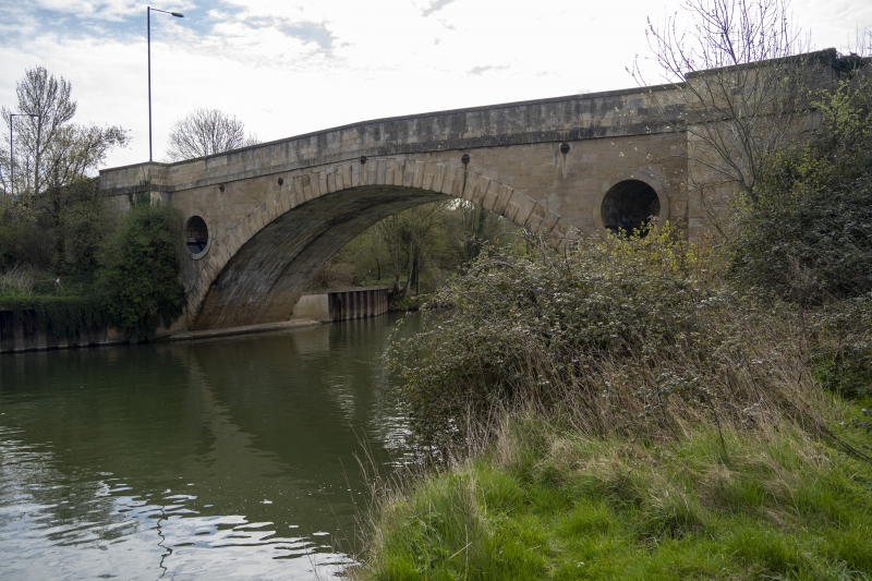
Bridge. Originally 1727 with 3 arches by John Strahan. Rebuilt with single arch in late C18, widened by William Armstrong of Bristol in 1831-1834.
MATERIALS: Limestone ashlar.
PLAN: Single segmental arch spanning 28m, with approaches at either end.
EXTERIOR: Main arch has rusticated voussoirs, spandrels lightened by circular tunnels with raised rim. Continuous platband above arch, cranked coped parapet. Projecting abutments with refuges at road level. Downstream abutments are plain, upstream ones have paired pilasters battered together to form pylon with sunk panel between. More monumental treatment was possibly because face of bridge can be seen by approaching traveller on high road. Approaches have 8 round headed arches with cut-waters to either side of bridge on up stream side. Bath side curving towards east. Blocked on downstream side suggests that no real intention to be flood arches, but way of building up embankment.
HISTORY: Bridge possibly completely rebuilt in 1830's, but visual evidence suggests (see soffit of arch) that it was widened on both sides from narrow late C18 bridge of more Pont-y-pridd type. At same time approaches were lengthened and built up to improve gradient. One of more major improvements by the Bath Turnpike Trust during the General-Surveyorship of John Loudon McAdam, 1826-1836. John Wood's `Description of Bath' (1749) states that drawings for original bridge were made by Mr Hobbs for John Strahan of Bristol but work executed by Ralph Allen, presumably as part of improvement of the River Avon Navigation (opened 1727).
Bridge formerly listed separately in Newton St Loe CP.
Listing NGR: ST7168065783
The asset was previously listed twice also under List entry 1365664. This entry was removed from the List on 12 December 2013.
External links are from the relevant listing authority and, where applicable, Wikidata. Wikidata IDs may be related buildings as well as this specific building. If you want to add or update a link, you will need to do so by editing the Wikidata entry.


Other nearby listed buildings
