Approximate Location Map
Large Map »
Latitude: 51.3809 / 51°22'51"N
Longitude: -2.3543 / 2°21'15"W
OS Eastings: 375440
OS Northings: 164707
OS Grid: ST754647
Mapcode National: GBR 0QH.CLJ
Mapcode Global: VH96M.4KR8
Plus Code: 9C3V9JJW+97
Entry Name: Viaduct Leading to North Parade Bridge, with Associated Lodges
Listing Date: 5 August 1975
Last Amended: 15 October 2010
Grade: II
Source: Historic England
Source ID: 1395834
English Heritage Legacy ID: 511242
ID on this website: 101395834
Location: Dolemeads, Bath and North East Somerset, Somerset, BA2
County: Bath and North East Somerset
Parish: Non Civil Parish
Built-Up Area: Bath
Traditional County: Somerset
Lieutenancy Area (Ceremonial County): Somerset
Tagged with: Architectural structure Viaduct
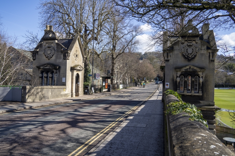
NORTH PARADE ROAD
Nos.1 AND 2
Viaduct leading to
North Parade Bridge,
with associated lodges
(Formerly Listed as:
NORTH PARADE
North Parade Bridge
including lodges)
05/08/75
GV II
Viaduct with two associated tollhouses. 1836. By William Tierney Clarke, engineer, tollhouses possibly designed by Edward Davis .
MATERIALS: Limestone ashlar, with Welsh slate roofs to tollhouses.
EXTERIOR: Five arch viaduct, semicircular arches with console keyed heads, platband, parapet wall possibly later, broken through at entrance to Sports Centre. Only first arch open, others are walled in, slightly recessed from face of viaduct. Viaduct leads from embankment at east end up to level of North Parade Bridge, which had to be at level of already existing North Parade (qv). Two former tollhouses stand on either side of roadway at junction of embankment and viaduct. One room plan, Jacobean style. One storey and attic with cellar below level of roadway. Symmetrical, but opposites. Arched doorway with pedimented head, and roundel over in gable, faces onto road. Tripartite oriel with pediment faces along bridge, each light four-paned, pilasters are `Jacobean' balusters. Coat-of-arms in cartouche over, shaped gable with pierced segmental pediment over that. Elevation repeated facing along embankment. Another oriel on elevation away from road. Also has gable as road elevation, small chimney above. Base with horizontal rustication below road level.
INTERIORS: Not inspected.
HISTORY: An elaborate piece of civic improvement, unusual for employing the nascent Tudorbethan style for its architectural effect.
SOURCES: Jackson N: Nineteenth Century Bath - Architects and Architecture: Bath: 1991-: 205.
Listing NGR: ST7544064707
External links are from the relevant listing authority and, where applicable, Wikidata. Wikidata IDs may be related buildings as well as this specific building. If you want to add or update a link, you will need to do so by editing the Wikidata entry.


Other nearby listed buildings
