Approximate Location Map
Large Map »
Latitude: 51.6159 / 51°36'57"N
Longitude: -0.7114 / 0°42'41"W
OS Eastings: 489314
OS Northings: 191577
OS Grid: SU893915
Mapcode National: GBR D5D.LYY
Mapcode Global: VHDW5.MN82
Plus Code: 9C3XJ78Q+9C
Entry Name: Milestone in Front of the Halfway House
Listing Date: 9 November 2010
Grade: II
Source: Historic England
Source ID: 1396000
English Heritage Legacy ID: 505552
ID on this website: 101396000
Location: Wycombe Marsh, Buckinghamshire, HP11
County: Buckinghamshire
Electoral Ward/Division: Ryemead
Parish: Non Civil Parish
Built-Up Area: High Wycombe
Traditional County: Buckinghamshire
Lieutenancy Area (Ceremonial County): Buckinghamshire
Church of England Parish: High Wycombe Saint Anne and Saint Peter
Church of England Diocese: Oxford
Tagged with: Milestone
818/0/10009 LONDON ROAD
09-NOV-10 706
Milestone in front of the Halfway House
II
Stone milestone, four-sided with shallow curved top.
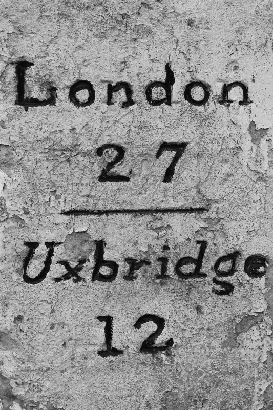
DESCRIPTION: This milestone is located just outside the boundary of the Halfway House public house on London Road (A40). It is inscribed on the west facing side: 'XXXV, London, 1744'. The front facing (north) side is inscribed: 'London 27, Uxbridge 12'. The east facing side is inscribed: 'Oxford 27, Wycombe 2' - in a slightly different style to the other faces and may be a later recarving of the original stone as is known to have happened elsewhere on milestones on this route.
Other milestones surviving on this particular turnpike route include milestones at Stokenchurch, dated 1744 (Grade II); Loudwater, Chepping Wycombe, dated 1744 (Grade II), Denham, known to have been at their current location from c1799 as shown on a map of that date.
This milestone appears to be in a better state of repair than one approximately a mile to the east at Loudwater (listed Grade II).
HISTORY: From the late C17 to the mid C18 many turnpike trusts were established along roads connecting London with major provincial cities. Milestones became prevalent in the mid C18 when turnpike trusts were encouraged to provide such makers, the 1744 Turnpike Act supposedly making it compulsory on most turnpike roads. This milestone was perhaps set up in response to that statute, being as it does the inscribed date 1744. It stands on the road from Oxford to London. Milestones are notable as testaments to the development of the transport network. The early and mid C18 represent a significant phase in the development of the national road network, with the establishment of well maintained highways under the turnpike system becoming prevalent.
Old maps show that the milestone was in its current location in 1876, which would indicate that it has not moved in the past 150 years.
SOURCES: Wright, Geoffrey N: Turnpike Roads, Shire publications, 1992.
REASONS FOR DESIGNATION
The milestone at Grid SU892915 on the London Road (A40) in High Wycombe is designated for the following principal reasons:
* It is of early date (inscribed 1744), probably placed as a consequence of the 1744 Turnpike Act requiring milestones on many established turnpike roads
* It is a notable testament to the development of the national transport network, at an important and formative period in the history of road transportation;
* It is in good condition, with all inscriptions fully legible, and has been in the same location since 1876 at least;
* It forms part of a group of similar or comparable C18 milestones along this same important route connecting Oxford to London.
Yes list
The milestone at Grid SU892915 on the London Road (A40) in High Wycombe has been designated for the following principal reasons:
* It is of early date (inscribed 1744), probably placed as a consequence of the 1744 Turnpike Act requiring milestones on many established turnpike roads;
* It is a notable testament to the development of the national transport network, at an important an formative period in the history of road transportation;
* It is in good condition, with all inscriptions fully legible, and has been in the same location since 1876 at least;
* It forms part of a group of similar or comparable C18 milestones along this same important route connecting Oxford to London.
External links are from the relevant listing authority and, where applicable, Wikidata. Wikidata IDs may be related buildings as well as this specific building. If you want to add or update a link, you will need to do so by editing the Wikidata entry.


Other nearby listed buildings
