Approximate Location Map
Large Map »
Latitude: 51.7503 / 51°45'1"N
Longitude: -2.3068 / 2°18'24"W
OS Eastings: 378917
OS Northings: 205777
OS Grid: SO789057
Mapcode National: GBR 0L3.CKP
Mapcode Global: VH94W.Y8VK
Plus Code: 9C3VQM2V+47
Entry Name: Newtown Lock, spill weir and boundary markers
Listing Date: 22 July 2011
Grade: II
Source: Historic England
Source ID: 1400205
ID on this website: 101400205
Location: Newtown, Stroud, Gloucestershire, GL10
County: Gloucestershire
District: Stroud
Civil Parish: Eastington
Traditional County: Gloucestershire
Lieutenancy Area (Ceremonial County): Gloucestershire
Church of England Parish: Eastington St Michael and All Angels
Church of England Diocese: Gloucester
Tagged with: Lock
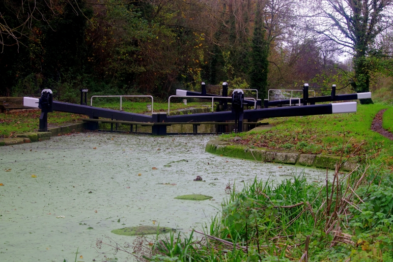
Canal lock and adjacent spill weir. Constructed circa 1777 for the Stroudwater Canal Company. Later alterations, and restored in the late C20.
MATERIALS: The lock chamber is built of red brick with ashlar dressings; the spill weir is constructed of stone and red brick.
DESCRIPTION: The single pound LOCK has brick retaining walls surmounted by large ashlar coping stones. There are stone quoins to the gate recesses at the upper and lower ends of the chamber. The pairs of timber gates were replaced in the late C20; iron fittings restrain the gateposts. The associated SPILL WEIR is situated on the towpath (north) side of the lock and formed part of the site's water management system: an overflow device for ensuring the canal water levels remained stable. It consists of an open trough into which the overspill flowed. The overflow channel leading underground from the trough has three shallow, segmental-arched openings in brick which spring from stone jambs and a central chamfered stone. The railings now enclosing the spill weir are not original.
SUBSIDIARY FEATURES: the group also includes two roughly-carved stone boundary markers. They are situated on the south side of the canal, at either end of the lock pound, and appear to date from the late C18.
The Stroudwater Navigation, built in 1775-9, was designed to link the River Severn at Framilode to Stroud, allowing coal to be brought from Shropshire, Staffordshire and the Forest of Dean to the textile mills of the Stroud valleys. The Thames and Severn Canal, constructed in 1783-9, was designed to run eastwards from Stroud, eventually linking the River Severn to the River Thames at Inglesham, near Lechlade. The Cotswold Canals, as they are also known, were generally successful, though the Thames and Severn in particular suffered serious technical failings which compromised its profitability; despite this, both canals continued in use well into the C20.
Newtown Lock was constructed circa 1777 and was the top lock of a flight of five locks on the Eastington section of the Stroudwater Navigation. It was designed to accommodate Severn trows. Originally intended to be known as Upper Nassfield Lock, historic documents indicate that Newtown Lock was previously recorded as Eastington Top, or Top Lock of Five. The pound was repaired in 1825; the top gates renewed in 1876; and the lower gates in 1864 and 1907. The lock and the adjacent spill weir were restored in the 1990s; the first lock to be restored by the Cotswolds Canal Trust.
Newtown Lock, the adjacent spill weir and boundary markers are designated at Grade II for the following principal reasons:
Intactness: despite restoration, the lock and the spill weir retain a good proportion of historic fabric
Group value: as a good group of contemporary canal structures which includes less common features such as the semi-circular spill weir and canalside boundary markers
Functional relationship: the lock and the spill weir form a cogent and functionally-related group which demonstrates clearly how such structures operated together
External links are from the relevant listing authority and, where applicable, Wikidata. Wikidata IDs may be related buildings as well as this specific building. If you want to add or update a link, you will need to do so by editing the Wikidata entry.


Other nearby listed buildings
