Approximate Location Map
Large Map »
Latitude: 53.6672 / 53°40'1"N
Longitude: -1.8391 / 1°50'20"W
OS Eastings: 410725
OS Northings: 418979
OS Grid: SE107189
Mapcode National: GBR HVL1.M4
Mapcode Global: WHCB0.Q2DZ
Plus Code: 9C5WM586+V8
Entry Name: C18 guide stoop (signpost) at junction of Crosland Road and Lindley Moor Road
Listing Date: 9 August 2011
Grade: II*
Source: Historic England
Source ID: 1403442
ID on this website: 101403442
Location: Blackley, Kirklees, West Yorkshire, HD3
County: Kirklees
Electoral Ward/Division: Lindley
Parish: Non Civil Parish
Traditional County: Yorkshire
Lieutenancy Area (Ceremonial County): West Yorkshire
Church of England Parish: Lindley St Stephen
Church of England Diocese: Leeds
Tagged with: Architectural structure Guidestone
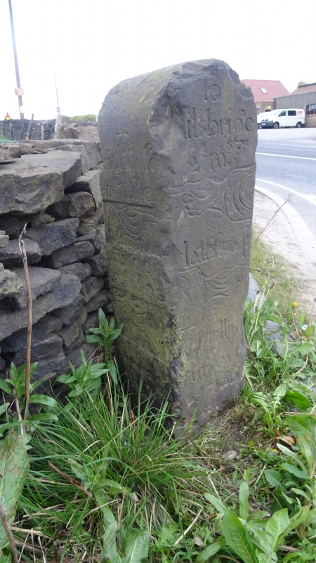
Sign post dated 1755 in the form of a squat, inscribed stone pillar.
Signpost, 1755, local gritstone pillar of rectangular cross section standing just less than 1m high. Two faces are inscribed with approximate (customary) mileages and depictions of pointing hands complete with cuffs. The stone has suffered some minor damage including the loss of some lettering.
NORTH-EAST FACE
This has a semi-circular top and is inscribed:
To
.ilsbrige
2 ms
[hand pointing left]
Hallif.. 4
[hand pointing right]
A Mallin....
Surveyo.
1755
This is interpreted as reading:
To Milnsbridge 2 miles, Halifax 4 miles, A Mallinson Surveyor 1755.
SOUTH-EAST FACE
This has a sloping top and is inscribed:
To
.righouse
iii mile.
[hand pointing right]
Marsden
5 miles
[Hand pointing left]
[Ordnance Survey benchmark]
This is interpreted as reading:
To Brighouse 3 miles, Marsden 5 miles
At the time of the inspection, the north-east face (otherwise blank) carried a modern, yellow, water hydrant plaque which is not of interest.
Mapping Note: The associated mapping marks the location of the Guide Stoop with a triangle; it is not intended to define an area on the ground.
The long ridge between the Colne and Calder valleys has been used as a route up to the Pennines since at least the Roman period. The guide stoop (signpost) dates to around the time that Lindley Moor was enclosed in the mid C18, the stone carrying the date 1755. The stoop marks a former crossroads of the old route between Brighouse and Marsden (which mainly follows the ridge) and a north-south route between Halifax and Milnsbridge. It is very similar in style to another guide stoop dated 1755 which is sited on another former crossroads further west along the ridgeway. This other post is adjacent to the Royal George public house on New Hey Road and was listed Grade II* in 1985. In 1806 the route became a turnpike road linking Huddersfield to New Hey in Rochdale. The post is marked on the 1854 Ordnance Survey map as being in the middle of Lindley Moor Road at the junction of Crosland Road, but on the 1894 map as being on the east side of the junction where it is still shown in 1938, with a milestone marked on the north side of the road. Crump (1949) writes in agreement with the map evidence. It is not known when the stone was moved to its current location on the south west side of the junction.
REASONS FOR DESIGNATION DECISION:
The guide stoop (signpost) of 1755 at the junction of Crosland and Lindley Moor Roads is listed at Grade II* for the following principal reasons:
* Date: As a rare, relatively well-preserved, mid C18 guide stoop (signpost).
* Design: For the interest of the style of carving.
* Historical: That it provides evidence of pre-turnpike road transport links between four places, recording distance in customary (rather than measured) miles.
* Relationship: The relationship between this and the similar guide stoop at the Lower Royal George Public House is rare at this date.
* Position: The signpost is believed to have marked the same road junction throughout its history.
External links are from the relevant listing authority and, where applicable, Wikidata. Wikidata IDs may be related buildings as well as this specific building. If you want to add or update a link, you will need to do so by editing the Wikidata entry.


Other nearby listed buildings
