Approximate Location Map
Large Map »
Latitude: 53.8067 / 53°48'23"N
Longitude: -1.7759 / 1°46'33"W
OS Eastings: 414853
OS Northings: 434508
OS Grid: SE148345
Mapcode National: GBR JDD.7Z
Mapcode Global: WHC98.PLJ3
Plus Code: 9C5WR64F+MJ
Entry Name: Nos. 1 & 3 Lilycroft Place (including garden wall, gate piers, gates and outbuildings)
Listing Date: 30 January 2012
Grade: II
Source: Historic England
Source ID: 1404510
ID on this website: 101404510
Location: Manningham, Bradford, West Yorkshire, BD8
County: Bradford
Electoral Ward/Division: Manningham
Parish: Non Civil Parish
Built-Up Area: Bradford
Traditional County: Yorkshire
Lieutenancy Area (Ceremonial County): West Yorkshire
Church of England Parish: Manningham St Paul and St Jude
Church of England Diocese: Leeds
Tagged with: Building
Former farmhouse of c1828 subdivided into two cottages in mid-late C19.
MATERIALS: Slender, sandstone 'bricks' laid in diminishing courses with ashlar dressings, stone slate roof.
PLAN: Irregular L-shaped building now divided into two properties; the western one third forming no.1, and the eastern two thirds forming no.3.
EXTERIOR: Two rendered ridge stacks with that to east end heavily truncated. Front (south) elevation: 4 bays (bay 1 forms no.1, and bays 2-4 form no.3), with a stone dentil cornice and large two-light stone mullioned windows with ashlar surrounds. No.1 has a window to each floor (both with uPVC glazing) with a doorway to ground floor right with painted ashlar surround and a modern, partly-glazed door. Attached in front is a modern, single-storey, open timber lean-to with a corrugated plastic roof, which is not of special interest. No.3 has a central doorway with a mid-late C20 glazed porch attached in front with a random rubblestone base. Windows to each floor of outer bays contain top-hung timber casements. West side elevation: Rendered gable end and west wall of lean-to, with a small window to ground floor of lean-to. East side elevation: Two large ashlar springers at base of gable. Rear (north) elevation: four bays (bays 2 & 3 form no.3, bay 4 forms no.1) with roughcast-rendering and painted ashlar sills to windows. North-east corner of building depicted on historic OS maps (bay 1) has been demolished, probably in the mid C20. Mid-late C19, 1 1/2 storey lean-to (shared between the two properties) attached to western two-thirds of elevation forms a catslide roof, from which another small stack rises. Recessed doorways with modern doors to ground floor of each bay. Bays 2 & 3 also have windows to left of each door; a top-hung casement and four-light fixed pane window respectively. Top-hung casement to first floor of bay 2, five-light casement window to first floor of bay 3. Enlarged window to first floor of bay 4 with uPVC glazing.
INTERIOR: No.3: Two large rooms to both floors in main range with two additional rooms to both floors in rear lean-to. Replaced doors to ground floor, four-panel doors to first floor. Windows to rooms in main range have angled reveals and window seats. Small stair hall set behind entrance porch contains an enclosed stair flight and has a room off to each side. Principal ground-floor rooms with painted beams running east-west and flanking chimneybreasts, with an original timber fire surround in the eastern room. Western room with C20 fire surround and electric fire, door in east wall originally led down to the basement but is now sealed off, doorway in west wall leads into rear lean-to containing a modern kitchen with original chimneybreast. Doorway in east wall of kitchen leads into eastern lean-to room (believed to have originally had an agricultural function) with a lower floor level accessed via stone steps, a stone flag floor, exposed ceiling joists with some iron hooks, trapdoor to floor above (now fixed in place), a late C20 toilet and a sink. First floor bedrooms to main range with chimneybreasts and painted beams. Later partition wall with internal windows inserted to rear of western bedroom to create a corridor accessing the rear lean-to. First floor lean-to rooms with exposed purlins and lower floor level; that to western end contains a bathroom, whilst that to eastern end has trapdoor access to room below (hidden under later coverings) and was probably originally a hayloft. C20 panelling to east wall.
No.1: One room to each floor of main range with an additional room to each floor of rear lean-to. Modern laminate flooring is laid on top of concrete to ground floor, six-panel doors and original floorboards to first floor. Modern kitchen to ground floor of lean-to and chimneybreasts to both floors in main range. Ground floor room has two painted beams running east-west identical to those in no.3, a modern fireplace, an enclosed stair flight to south-west corner with concertina-style, panelled timber door to bottom step and an under-stair storage area with six-panel door. First floor lean-to room with an exposed painted purlin and modern bathroom. Room to first floor of main range with a painted beam running north-south with a cut recess to underside of centre point. Hatch on first-floor landing accesses the roof. Roof has a party wall separating roof space of no.1 from that of no.3, flat-chamfered purlins and a single queen post roof truss to eastern end.
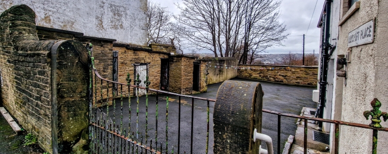
SUBSIDIARY FEATURES: Garden areas to southern side and yard area to northern side of building all enclosed by a low sandstone wall with mainly rounded copings. Simple stone gate piers with rounded heads exist to south section of wall in line with the entrance to no.3. Western section of wall bordering Heaton Road is taller and possibly later in date, and incorporates gate piers in same style as those to southern section of wall with a wrought-iron vehicular gate and pedestrian gate. Rear yard area is paved with stone setts and flags and contains a range of small, single-storey, flat-roofed outbuildings (storage and outdoor toilets) to north side with plank and batten doors.
The village of Manningham is believed to date to Saxon times and is thought to be one of six outlying dependencies of the manor of Bradford noted, but not named, in the Domesday Book. Until c1850 Manningham was still physically remote from Bradford and was a small rural township characterised by weavers' cottages, farmhouses and agricultural land, and a few wealthy villas, with the old village core centred around what is now St Paul's Church (1847). However, Manningham's population subsequently began to increase rapidly in the mid-late C19 as Bradford's worsted and silk trade developed; an expansion escalated by the opening of Manningham railway station in 1860 and the sale of plots of land for the development of middle class housing. The construction of long terraces of houses and back-to-back housing throughout Manningham during the late C19 and early C20, partly in order to serve the vast Manningham Mills (1870-3) and its 4000+ workforce, eventually engulfed the original village and Manningham became a suburb of Bradford.
Nos. 1 & 3 Lilycroft Place are believed to date to the early C19 and a date of c1828 has been suggested. The building is depicted on a map of the Borough of Bradford surveyed in 1844-6. Nos.1 & 3 Lilycroft Place are believed to have originally been a single farmhouse that was later split into two properties in the mid-late C19 (pre-1893) with a rear lean-to probably added at the same time. At the time of the building's construction it would have been situated on the south-western edge of the village and surrounded by farmland. In 1994 the windows of no.1 were replaced with uPVC units and in 1997 the rear elevation was re-rendered.
Nos. 1 & 3 Lilycroft Place are designated at Grade II for the following principal reasons:
* Urban setting: They are an important physical reminder of Manningham's agricultural origins before it was transformed into one of the world's most industrious suburbs of the mid C19-early C20
* External survival: Their original identity as a single farmhouse remains clearly identifiable and the front elevation incorporates a modest level of architectural treatment above the purely functional
* Interior features: Despite some later alteration many original features survive, both domestic, such as a fireplace, window reveals and window seats, and agricultural, including exposed ceiling joists with iron hooks, and a trapdoor to the former hayloft above
* Group value: They have group value with the nearby Grade II listed terraces of cottages on Church Street (c1820-30) and Heaton Road (c1840), and nos.11, 13 and 15 Skinner Lane (an early-mid C18 farmhouse subdivided into cottages c1800-1820) in being representative of the old village of Manningham
External links are from the relevant listing authority and, where applicable, Wikidata. Wikidata IDs may be related buildings as well as this specific building. If you want to add or update a link, you will need to do so by editing the Wikidata entry.


Other nearby listed buildings
