Approximate Location Map
Large Map »
Latitude: 50.7228 / 50°43'22"N
Longitude: -2.4435 / 2°26'36"W
OS Eastings: 368786
OS Northings: 91559
OS Grid: SY687915
Mapcode National: GBR PY.QS7M
Mapcode Global: FRA 57R5.KTM
Plus Code: 9C2VPHF4+4H
Entry Name: Road bridge to south-east of Lower Burton Mill
Listing Date: 12 July 2012
Grade: II
Source: Historic England
Source ID: 1410147
ID on this website: 101410147
Location: Frome Whitfield, Dorset, DT2
County: Dorset
Civil Parish: Charminster
Traditional County: Dorset
Lieutenancy Area (Ceremonial County): Dorset
Church of England Parish: Charminster St Mary the Virgin
Church of England Diocese: Salisbury
Tagged with: Road bridge
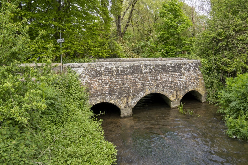
Road bridge over river, late C18.
The bridge is constructed of red brick in stretcher bond, with stone to the arches. It is aligned north to south, crossing the river with three elliptical-headed arches that have dressed-stone voussoirs. The flanking arches are slightly narrower than the central one. Two iron ties have been added through the bridge to either side of the central arch. The parapet walls are plain and have stone copings. The south end of the east face of the bridge terminates in a brick pier; the west side has an attached stone rubble wall which forms the boundary to Lower Burton Mill.
Turnpiking of the main roads was relatively late in Dorset; part of the Great Western Road that runs through the northern part of the county was turnpiked through Sherborne and Shaftesbury in 1753, and turnpiking in the rest of the county then proceeded rapidly during the 1760s. The Sherborne and the Shaftesbury trusts (created by the division of the first 1753 trust) took into their control a network of secondary and tertiary routes that converged on the market towns. The road bridge at Lower Burton, immediately to the east of Lower Burton Mill Dorchester, carries the Sherborne (via Cerne Abbas) road over the main channel of the River Cerne and was previously part of the Weymouth, Melcombe Regis and Dorchester turnpike (1760-1878). The bridge is depicted on the tithe map of 1839 and is considered to date from the late C18.
The road bridge to the south-east of Lower Burton Mill which dates from the late C18 is designated at Grade II for the following principal reasons:
* Architectural interest: a well-constructed late-C18 bridge that is in original condition with some minor repairs;
* Historic interest: for its association with the former Weymouth, Melcombe Regis and Dorchester turnpike and as one of several bridges along this route.
External links are from the relevant listing authority and, where applicable, Wikidata. Wikidata IDs may be related buildings as well as this specific building. If you want to add or update a link, you will need to do so by editing the Wikidata entry.


Other nearby listed buildings
