Approximate Location Map
Large Map »
Latitude: 51.2165 / 51°12'59"N
Longitude: 0.3765 / 0°22'35"E
OS Eastings: 566068
OS Northings: 149046
OS Grid: TQ660490
Mapcode National: GBR NQ9.L0H
Mapcode Global: VHJMJ.GPWB
Plus Code: 9F32698G+HH
Entry Name: L-shaped farm building at Bullen Farm
Listing Date: 6 November 2012
Grade: II
Source: Historic England
Source ID: 1411841
ID on this website: 101411841
Location: Addlestead, Tonbridge and Malling, Kent, TN12
County: Kent
District: Tonbridge and Malling
Civil Parish: East Peckham
Traditional County: Kent
Lieutenancy Area (Ceremonial County): Kent
Church of England Parish: East Peckham
Church of England Diocese: Rochester
Tagged with: Agricultural structure
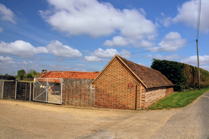
Cartshed of late C18 or early C19 date, extended by the mid C19 and later part of a cattle yard.
DATE: the northern range was probably constructed in the late C18 or early C19 as a cart shed and the eastern range was probably added in the mid-C19. Both parts are shown on the 1872 Ordnance Survey map, by which time the buildings were part of a cattle yard, but the southern end of the eastern side was lopped off in 1982 to provide a wider access for large vehicles. The south end wall and possibly the west were rebuilt in the later C20. The C20 structure with a corrugated iron roof attached at the south-east angle is not of special interest.
MATERIALS: the rear and side walls are constructed of brick and the open fronts are supported on timber piers. The roof is covered in peg-tile, except for the western slope of the eastern side where C20 tiles were replaced following theft.
PLAN: originally a single-storey range of six bays to the north with a four-bay range added later at the south-east end to form an L-shape.
DESCRIPTION: the north range has a north brick wall in Sussex bond. The west-end wall is also in Sussex bond but rebuilt in the C20. The open front to the south is supported on posts with curved jowls with curved wind braces on splayed pad stones. The roof structure has tie beams and rough-cut rafters with a ridge piece. Some thin rustic collar beams were nailed on later. The western bay contains two wide C19 brick fireplaces with segmental arches and chimneys set at right angles to each other, each with iron bars and hooks for hanging cauldrons. These were added in the C19 for communal cooking by seasonal hop pickers. Attached at the south-west end is a C19 wall of Kentish ragstone rubble with brick coping, forming one side of a cattle yard. On the inner side is a full-length concrete C20 cattle feeding trough. The east range has a brick wall in Flemish bond on the east side with a pattern of grey headers. The south end wall was rebuilt in the later C20, also in Flemish bond. The east range is open fronted on the west side, supported on un-jowled posts with wide wooden knees above, part bolted, part pegged. The roof structure of the east range has tie beams and sawn rafters with a ridge piece. The south bay is partitioned off with horizontal weatherboarding.
This L-shaped farm building is shown on the 1872 Kent six inch Ordnance Survey map, and subsequent 6 inch and 25 inch editions, enclosing the north and east sides of a closed yard, probably a cattle yard. However it appears from differences in the timber framing and rear brick walls that the north side was probably constructed first, possibly as a cart shed, in the late C18 or early C19, and the east side added in the mid-C19. The two brick chimneys were inserted into the western bay of the north range in the first half of the C19 for its use as a hop pickers' kitchen during the hop-picking season and the building was also probably used seasonally to house hop pickers before the construction of hop pickers' huts. In September 1849 an outbreak of cholera had killed 43 hop pickers in East Farleigh, also in Kent, and as a result there were campaigns to improve the conditions of the hop pickers which led to the erection of dedicated Hoppers Huts. The early ones were constructed of timber, brick huts were constructed after 1850 and later C19 ones were clad in corrugated iron.
The building ceased to be used for housing cattle in 1969.
This L-shaped farm building is designated for the following principal reasons:
* Architectural: a substantially intact open-fronted cartshed of late C18 or early C19 date, extended by the mid C19 and later part of a cattle yard;
* Rarity: the chimney with two ovens inserted for seasonal use as a hop pickers' kitchen is evidence of an important, very labour intensive regional industry. Hop pickers' kitchens, and other buildings associated with hop pickers, are now extremely rare both regionally and nationally;
* Group value: this building is part of a farm group with a listed barn and farmhouse.
External links are from the relevant listing authority and, where applicable, Wikidata. Wikidata IDs may be related buildings as well as this specific building. If you want to add or update a link, you will need to do so by editing the Wikidata entry.


Other nearby listed buildings
