Approximate Location Map
Large Map »
Latitude: 51.2822 / 51°16'56"N
Longitude: 1.0798 / 1°4'47"E
OS Eastings: 614871
OS Northings: 158182
OS Grid: TR148581
Mapcode National: GBR TY2.HT1
Mapcode Global: VHLGM.N1PC
Plus Code: 9F3373JH+VW
Entry Name: Abbot's Mill footbridge and sluice
Listing Date: 15 July 2014
Grade: II
Source: Historic England
Source ID: 1419121
ID on this website: 101419121
Location: Canterbury, Kent, CT1
County: Kent
District: Canterbury
Electoral Ward/Division: Westgate
Parish: Non Civil Parish
Built-Up Area: Canterbury
Traditional County: Kent
Lieutenancy Area (Ceremonial County): Kent
Tagged with: Footbridge
Abbot's Mill footbridge and sluice, dated 1829, controls the flow of the River Stour, and is associated with Abbot's Mill, an C18 water mill which stood on the site of successive earlier mills, adjacent to the footbridge and sluice.
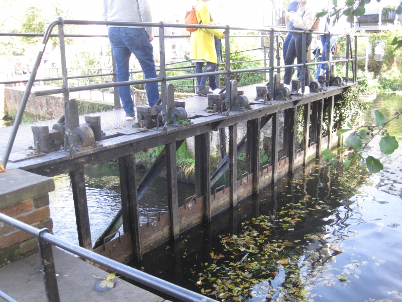
Abbot's Mill footbridge and sluice is a cast-iron structure, dated 1829 which controls the flow of the River Stour at this point. The structure is comprised of two principal elements – a footbridge, and a sluice adjoined to the up-river (south) side of the bridge. The structure is approximately 7m wide, spanning from the west bank of the Stour, to the southern tip of the river island which separates the river from the millrace which originally drove Abbot's Mill.
The bridge is supported on two decorative spandrels, that to the north (downstream) bears the date at the centre, that to the south (upstream) is hidden by the sluice mechanisms. The sluice comprises six cast-iron mechanisms supported on the bridge above. Each mechanism controls a single main paddle, and each paddle is separated from the next by a vertical iron strut. Additional sheet metal paddles can be put on top of the main paddles – one to either side of each paddle-lifting mechanism, making a total of up to 12 additional paddles. The main paddles and the lifting mechanisms appear original to the 1829 date of the structure but the additional smaller paddles are modern replacements. The handrails to either side of the bridge have metal uprights and two horizontal metal bars. That to the downstream side appears original, with rats-tail finials, and solid, cast uprights; that to the upstream side is later: the rails are modern and the uprights are formed of flat bar, twisted at the base and held with a small backstay – these may be late C19 or early C20. The whole structure is braced with raked stays to the downstream side; the one to the east appears to be a later replacement. The surface of the bridge is now covered in a modern tread-plate.
Abbot's Mill footbridge and sluice was constructed in 1829. The sluice controls the flow of the River Stour as it bypasses the millrace which powered Abbot's Mill (the site of which, approximately 40m to the north-east, is a Scheduled Monument). A mill is understood to have existed on the site since the early medieval period, but the last mill to have stood here was built in 1792. The mill was a large six-storey building designed by the engineer John Smeaton. It was worked by a succession of tenants, and in the late C19 came into the ownership of the Denne family, when it became known as Denne's Mill. In 1933 the mill was destroyed by fire.
Abbot's Mill footbridge and sluice of 1829 is listed at Grade II for the following principal reasons:
* Design interest and level of survival: the structure is a handsome, operational example of early C19 engineering, unusual for having only minor alterations and additions its original fabric;
* Historic interest and group value: the structure is adjacent to, and functionally associated with, the scheduled Abbot's Mill site (NHLE 1004198).
External links are from the relevant listing authority and, where applicable, Wikidata. Wikidata IDs may be related buildings as well as this specific building. If you want to add or update a link, you will need to do so by editing the Wikidata entry.


Other nearby listed buildings
