Approximate Location Map
Large Map »
Latitude: 51.8684 / 51°52'6"N
Longitude: -2.243 / 2°14'34"W
OS Eastings: 383363
OS Northings: 218902
OS Grid: SO833189
Mapcode National: GBR 1KZ.XBK
Mapcode Global: VH94C.29KH
Plus Code: 9C3VVQ94+9Q
Entry Name: The Remains of Tanners' Hall
Listing Date: 29 July 2015
Grade: II
Source: Historic England
Source ID: 1422933
ID on this website: 101422933
Location: Gloucester, Gloucestershire, GL1
County: Gloucestershire
District: Gloucester
Electoral Ward/Division: Westgate
Parish: Non Civil Parish
Built-Up Area: Gloucester
Traditional County: Gloucestershire
Lieutenancy Area (Ceremonial County): Gloucestershire
Church of England Parish: Hempsted with Gloucester, Saint Mary de Lode and Saint Mary de Crypt
Church of England Diocese: Gloucester
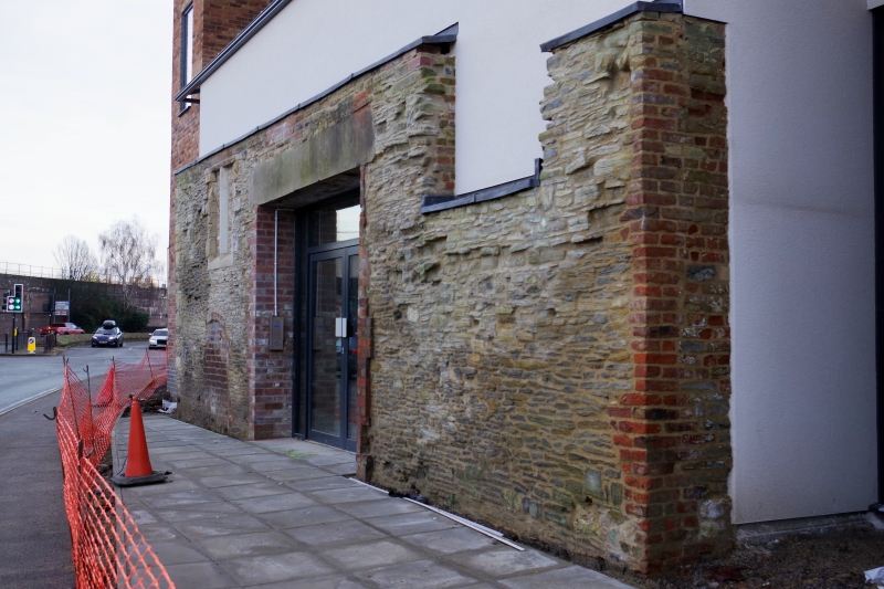
A C13 town house, taken over by the Company of Tanners in 1540 and used as a tannery until the C18, it now (2015) survives as a ruin.
A C13 town house, taken over by the Company of Tanners in 1540 and used as a tannery until the C18, it now (2015) survives as a ruin.
MATERIALS: mainly stone and brick.
PLAN: a rectangular building on an east to west alignment.
DESCRIPTION: three walls remain and these incorporate medieval building fabric, including some fragments of doors and windows. The building measures 10.2m east-west and 5.25m north-south. The east and west walls are each 0.5m wide, and the north wall is 1.1m wide. The walls stand up to circa 3.7m high. The north wall contains the largest surviving sections of medieval walling, with over half remaining. Some timber joists and lintels remain intact and the position of early windows can be seen in the north wall including a surviving mullion window on the left-hand side and an opening below. In the centre is a large rectangular opening with a concrete lintel has been punched through in the C20 and a further opening to the right. The east wall, which has largely been rebuilt, also retains medieval fabric. Part of the gabled medieval west wall has been incorporated in the post-medieval fabric. The south wall no longer exists above ground level.
The house is a stone-built rectangular C13 merchant’s house with a first-floor hall. It was taken over by the Company of Tanners in 1540 and was used as a tannery until the C18. In the late C18 the ground floor was subdivided, and part of the building floored with bricks and mortar. In another part, a hearth-base for a vat was built. In the mid-C19 it was converted into two cottages and a brick wall was constructed that further subdivided the building. Supports were built for an upper floor which had previously rested on stone corbels, and one of the ground-floor windows was converted into a door. The western part of the building was subsequently used as a paint shop. The south side of the building is depicted in a C19 drawing and shows that there were two upper windows on the south side which are thought to have had parallels on the north side. To the north, a later door and window apparently destroyed one of the original upper windows, and the truncation of the north wall led to the loss of the upper half of the remaining window. One of the ground-floor windows on this north side was converted into a door in the C19. A large opening was made in this elevation in the C20. A southern doorway and associated steps to the first-floor hall were in existence when the site was excavated in 1983. The building now (2015) survives as a ruin.
The upstanding remains were recorded in 1983. Excavation of several trial trenches located a series of rectangular and circular post-medieval tanning pits. It also revealed a medieval moulded pillar base which would have supported the upper floor, as well as evidence for five phases of occupation ranging from a Romano-British road to mid-C19 domestic occupation. Construction near to the hall in the late 1980s and 1990s, including the creation of inner relief road to the north of the hall, resulted in a number of excavations and archaeological monitoring in its immediate vicinity. These revealed further evidence of a Romano-British metalled road, C11 and C12 medieval activity and evidence of a tannery yard within which the hall stood. In 2011, further excavations were undertaken in the land surrounding Tanner's Hall. These revealed Roman, medieval and post-medieval deposits, including a medieval flag-stone floor, the foundations of a C15/C16 wall to the west of the hall and tannery pits to the south and east.
The remains of Tanners’ Hall, built in the C13 as a town house and used as a tannery from the C16 to the C18, is listed at Grade II for the following principal reasons:
* Relative date: the building's C13 date confers a good degree of special interest;
* Evolution: its evolution is represented in the fabric, and its early conversion from domestic to industrial use is of particular note;
* Historic interest: it represents the surviving remains of a medieval town house within Gloucester, which was subsequently associated used by the Company of Tanners, one of the oldest craft organisations in the city;
* Architectural interest: historic depictions show that it was once elaborately decorated and the building retains a significant proportion of medieval fabric within the later alterations, and clearly demonstrates its evolution from domestic to industrial use;
* Rarity: it is one of the few surviving remains of a stone-built medieval town house within Gloucester, and acts an important comparator for medieval secular buildings in other medieval urban centres within the region.
External links are from the relevant listing authority and, where applicable, Wikidata. Wikidata IDs may be related buildings as well as this specific building. If you want to add or update a link, you will need to do so by editing the Wikidata entry.


Other nearby listed buildings
