Approximate Location Map
Large Map »
Latitude: 54.8863 / 54°53'10"N
Longitude: -2.9193 / 2°55'9"W
OS Eastings: 341123
OS Northings: 555007
OS Grid: NY411550
Mapcode National: GBR 8C1Y.S5
Mapcode Global: WH803.4F3X
Plus Code: 9C6VV3PJ+G7
Entry Name: London Road NER Goods Station
Listing Date: 16 November 2015
Grade: II
Source: Historic England
Source ID: 1430159
ID on this website: 101430159
Location: Cumberland, Cumbria, CA1
County: Cumbria
District: Carlisle
Parish: Non Civil Parish
Built-Up Area: Carlisle
Traditional County: Cumberland
Lieutenancy Area (Ceremonial County): Cumbria
Church of England Parish: Carlisle St John the Evangelist
Church of England Diocese: Carlisle
Tagged with: Architectural structure
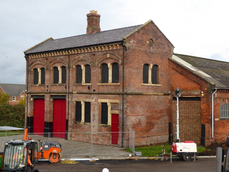
Railway goods sheds and office building, 1881, to the designs of William Bell, NER architect.
Railway goods sheds and office building, 1881, to the designs of NER architect William Bell.
MATERIALS: red brick laid in English bond with sandstone dressings; Welsh slate and asbestos roofs.
PLAN: rectangular, goods office aligned north to south with paired, through-road entrances at its north end flanking a two-bay office to the right. The double pile goods shed is attached to the rear elevation and projects for one bay to either side of the goods office, each bay containing a former rail entrance. The configuration of road and rail entrances combined with the building's depiction on the 1901 Ordnance Survey map, suggest that there were tracks in the most northerly and southerly bays of the goods shed with a central storage area and loading platform.
EXTERIOR: the station house or goods office has two storeys beneath a pitched roof of slate. It has a brick plinth and a stone band and prominent, copings, moulded watertables and a central ridge chimney stack. The main four-bay elevation comprises segmental arched panels rising through both floors. Their heads are formed by a continuous double-banded moulding with ornate stops, infilled with finely-gauged brickwork. To the ground floor left are paired, square-headed openings forming road entrances with chevron-decorated cast iron lintels, supported on carved stone corbels. To the right is a two-light square-headed mullioned window and a similar single-light window separated from an original entrance to the right by a stone mullion. All openings are boarded and the original fanlight to the entrance is blocked with brick. To the first floor the segmental arched panels frame arched, two-light windows with ornate stone mullions and stone sills; fenestration is missing from all but one of these windows. Above there is a bracketed cornice with sandstone dentils. The south gable has a two-light segmental-arched mullioned window to the first floor, with a keyed oculus above, set with a datestone of 1881. The north gable has a similar first floor window to that of the south gable.
Attached to the rear but with one bay projecting to either side of the goods office is the goods shed; each projecting bay has a large square-headed rail opening with steel jambs to the lower parts, now blocked with brick. The goods shed is single-storey and of double-pile construction and the roofs have a corrugated asbestos sheeting covering. The northern section of the shed is slightly narrower at its east end than the southern section and this is reflected in a slightly curving north wall and a slightly steeper pitch to the roof. The south elevation has fifteen bays defined by rectangular recessed panels with brick modillions, and there is a chamfered plinth, a stone sill band and a bracketed eaves cornice. The central bay contains a full-height segmental-arched and keyed opening, flanked by seven segmental-arched window openings with stone sills, recently re-fenestrated. The north elevation has three identical panels to its slightly curving eastern end, but the remainder of the elevation is blind. There is a bracketed eaves cornice and the brick wall has a stone plinth of about fifteen courses, suggesting that it incorporates an earlier feature. This elevation also has timber bearer marks running its full length, from an earlier roof projection, possibly an external platform or rail line associated with the earlier lime depot building. The east elevation comprises paired gables, the northern gable being narrower than the south, and each has an oculus with finely gauged brick voussoirs. The ground floor of the north section has paired segmental-arched road and rail openings with stone imposts and keystones and cast iron jambs to the lower parts acting as buffers. The ground floor of the south section has an identical rail opening at its left with a window opening to the right. Traces of a former C20 lean-to can be identified in this elevation.
INTERIOR: the goods office is largely open to the roof with the loss of floors and ceilings but partition walls remain, defining a stair hall with a stone dog leg stair and an office to the ground floor and a pair of offices to the first floor; these rooms retain few features with the exception of timber architraves, a brick chimney breast to the more northerly second first floor office and what appear to be gas pipes and mantles to the first floor. The recessed panels of the goods shed exterior are expressed internally on both north and south walls. The three road and rail openings in the east gable are fitted with a modern roller shutter and the paired road entrances at the west end have double timber boarded doors. A line of nine cast-iron columns run down the centre of the building carrying a lattice girder that supports the original double-pitched cast-iron roof structure; this comprises triangular braced trusses with continuous skylights to each pitch.
As stated above, structures beyond the blue line on the attached map do not form part of the listed building, these exclusions include (but are not limited to) the later, roofless, single storey building in the north west angle of the office and shed.
Following the transfer of the original passenger station of the Newcastle to Carlisle Railway (1836) to the Citadel site in 1863, the old station terminus at London Road became a goods depot. These buildings were demolished in 1881 and replaced with a new goods station; reported in the Carlisle Journal on 19-08-1881 as 'new offices and goods warehouse and engine shed'. This new building is depicted on the 1:2500 Ordnance Survey published in 1901 with largely the same footprint as the present day. This map also depicts tracks operating to the north and south openings of the engine shed. The stone base visible in the north wall of the new building indicates that it was built upon the remains of an earlier feature, which historic mapping suggests might have formed part of an earlier lime depot. Small, later buildings attached to the east and west gables have recently been removed.
The North Eastern Railway (NER) employed a salaried architect almost throughout its corporate life, and the new building was designed by William Bell, NER architect from 1877 to 1914.
The 1881 Carlisle North East Railway goods station at London Road is listed at Grade II for the following principal reasons:
* Architecture: a good quality design that expresses its function well, employing well-finished red brick and overall high quality detailing to both elements of the complex;
* Intactness: taken together, the buildings represent a complete example of a goods station comprising both a goods office and goods shed;
* Rarity: an increasingly rare survival of a large, urban goods station, whose interest is enhanced by the survival of a two-storey attached office building;
* Group value: the goods station benefits from a spatial group value with the adjacent (but earlier) Grade II listed Station Hotel and although not contemporary, the pair share a functional group value as C19 railway buildings.
External links are from the relevant listing authority and, where applicable, Wikidata. Wikidata IDs may be related buildings as well as this specific building. If you want to add or update a link, you will need to do so by editing the Wikidata entry.


Other nearby listed buildings
