Approximate Location Map
Large Map »
Latitude: 51.4521 / 51°27'7"N
Longitude: -2.604 / 2°36'14"W
OS Eastings: 358128
OS Northings: 172741
OS Grid: ST581727
Mapcode National: GBR C6L.29
Mapcode Global: VH88M.TR7P
Plus Code: 9C3VF92W+RC
Entry Name: 37 St George's Road
Listing Date: 5 October 2018
Grade: II
Source: Historic England
Source ID: 1460107
ID on this website: 101460107
Location: Canon's Marsh, Bristol, BS1
County: City of Bristol
Electoral Ward/Division: Hotwells and Harbourside
Parish: Non Civil Parish
Built-Up Area: Bristol
Traditional County: Gloucestershire
Lieutenancy Area (Ceremonial County): Bristol
Tagged with: Building
A former mid-C17 house, altered to become a brew house in the late C18. The house was extended forward in the C19 with a single-storey and two-storey addition. Early-C20 two-storey pub frontage. The mid- to late-C20 two-storey addition attached to the south elevation is not included in the listing.
A former mid-C17 house, altered to become a brew house in the late C18. The house was extended forward in the C19 with a single-storey and two-storey addition. Early-C20 two-storey pub frontage. The mid- to late-C20 two-storey addition attached to the south elevation is not listed.
MATERIALS: built of rubble stone that has been rendered. Rendered rubble stone gable end chimney stacks, with brick shafts. The roof has been recovered in clay pantiles. C20 windows.
PLAN: a single-pile, two-room plan with a central rear stair tower flanked by smaller rooms. Added to the front of the building is a C19 single-storey and two-storey addition that has filled the former courtyard. These additions are concealed from the street by an early-C20 two-storey pub frontage. The ground level of the rear courtyard has been raised with the creation of first-floor cellars beneath.
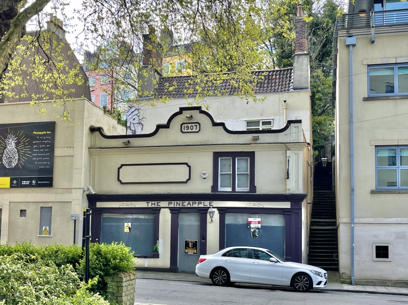
EXTERIOR: the three-storey C17 house, with a raised parapet and gable-end stacks is largely concealed by an early-C20, two-storey pub frontage. The pub frontage is built of brick laid in Flemish bond with stone dressings, now (2018) rendered and painted. It comprises a central doorway with flanking large windows with glazing bars to the upper section and plate glass beneath; the original stained glass has been removed. The window and door openings are flanked by Doric pilasters which, with the incised pilasters to the outer corners of the frontage, support the entablature above with dentils to the cornice and the name of the pub ‘THE PINEAPPLE’ to the frieze. There is decorative scrollwork to either side. To the right-hand side of the upper storey is a pair of horned sash windows with a shouldered stone architrave. The left-hand side is blind and has an applied rectangular frame with concave corners. This feature is repeated to the shaped parapet above the eaves cornice where it incorporates the date ‘1907’. The wrought iron bracket for the pub sign is mid- to late-C20.
To the side (north) elevation of the house, above an inserted first-floor doorway, is a C19 gas lamp.
The rear courtyard has been raised, and the first-floor rear elevation of the C17 house is now concealed by the first-floor cellars. The rear elevation of the second storey has a blocked window and various build-outs of stone of unknown function or date, beneath a catslide roof. The rear service range shows signs of rebuilding and has a flat roof.
INTERIOR: the C19 additions behind the pub frontage have been opened up, and the bar, fireplaces and seating removed; the matchboarding to dado height is mid- to late-C20. The central door and flanking window openings to the C17 house have been altered but are readable in the surviving masonry piers. The partition wall dividing the two principal rooms has been removed creating a single space into which the mid- to late-C20 bar has been inserted, incorporating a relocated C17 oak post with carved top. The C17 ceiling beam has ogee mouldings and end stops, and the break in the moulding indicates the former position of the partition wall between the two principal ground floor rooms. The original fireplace to the north room has been removed, and that to the south room appears to have been boarded up. Toward the rear of the north room is the chamfered doorhead leading to the central rear stair tower with a dogleg staircase with winder to the half-landings. The service rooms to either side are plain; that to the right leads to a barrel-vaulted room.
The parallel first-floor cellars to the rear of the building, one with a brick barrel vaulted ceiling, are probably mid- to late-C18, and encase the rear wall of the C17 house which retains a timber two-light mullion window with ovolo moulding.
The principal first-floor rooms have C17 ogee moulded ceiling beams with end stops, divided by a C17 timber partition wall; the wall post is visible to the north room. The south room has a deep window recess indicative of a canted bay or oriel window. This has been filled in to accommodate a C20 window. The two cupboards to either side of the chimney breast have C18 moulded architrave and C20 doors. The right-hand cupboard has C18 H-hinges. The front wall of the north room has been removed giving access to the two-storey C19 addition to the front of the building. To the rear wall of the north room is a C17 door frame with decorative moulding and stops. Within the sub-divided room beyond, to the north side of the stair tower, is the C17 two-light mullion window. The first floor balustrade has two mid-C17 pierced splat balusters. There are further pierced splat balusters to the second floor balustrade with relief carving of ionic capitals. The three second-floor door frames are C17 with moulding and stops to the jambs; one retains a C17 four-plank door with horizontal cross beams. The two principal rooms have cross axial ceiling beams with ogee moulding and end stops, and deeply recessed window openings that have been partially filled in to accommodate C20 windows. The staircase originally continued up to the attic but has been blocked and truncated, but there is evidence that it formed a stair tower with brick and stone walls and a truncated newel post with moulding within the roof space.
Within the attic are three C17 collar roof trusses, with wind braces to the east side. The ridge purlin has exposed oak staves suggesting the position of the original common rafters. The two-room plan is created from the central partition wall of timber studs and lath and plaster. Timber studs on the east and west sides of the two rooms rise from the attic floor beams to the common rafters to form vertical walls of lath and plaster. There are also fragments of lath and plaster ceilings. To the south room is a timber door frame with an iron pintel on its inner face. There are additional rafters above the west side of the C17 roof, carrying the catslide roof over the truncated stair tower and flanking rooms.
37 St George’s Road has origins as a mid-C17 house. The former house is located to the eastern side of Brandon Hill on an area of land historically known as West Hayes that fronted St George’s Road, then known as Cow Lane, and was owned by the Dean and Chapter of Bristol. Within their leases and indentures is a reference in 1665 to the land being in the possession of an Elizabeth Bishop as tenant to the Dean and Chapter. Elizabeth Bishop is thought to have been a woman of some wealth which is supported by her will of 1664 and its reference to a number of properties in her ownership, including on Cow Lane. She was also the sister of George Bishop, a significant figure in Cromwell’s government and a prominent leader in the Quaker movement.
A house in the location of 37 St George’s Road is depicted on Millerd’s map of Bristol (1673) as a three-bay house with a garden to the rear. An engraving of the view from Brandon Hill by Samuel and Nathaniel Buck in 1734 shows a house with a prominent viewing tower in the approximate location of 37 St George’s Road. These documents, combined with Rocque’s map (1750) suggest that it was a high status residence designed to take advantage of the views across Bishops Park to the city of Bristol.
By 1782 the lease records the house as a brew house, and the accompanying plan shows the building as having two canted bays or oriel windows to the front elevation, a rear wing (possibly a service range), a walled courtyard to the front of the house with a well and a central gateway onto the street, and a detached kitchen to the south of the courtyard. The brew house is recorded as the ‘Pine Apple’ in 1796, and by this time, as shown on the plan of the Dean and Chapter land of the same year, the detached kitchen had been demolished and replaced with terraced housing extending to the south, with stabling behind (demolished in the mid- to late C20). The historic maps show that the buildings to the rear of the property were altered throughout the C19 and C20 and only fragments of these buildings survive as garden walls, with a series of blocked former openings.
During the C19 the front courtyard was filled-in with a single-storey and two-storey addition, and in 1907 the pub frontage was added by the Bristol brewery Georges & Co Ltd. The architect was J A Wright. The 1906 planning drawing suggest that it was the C19 additions that formed the public areas (the smoke room, bar and a central passage leading to the bottle and jug counter), with a bar blocking public access to the C17 building, which at this time retained its two-room ground floor plan.
Two aerial photographs of 1926 show the principal elevation of the main house with a symmetrical arrangement of two raking dormer windows behind the parapet wall and ten-over-ten sash windows to the first and second floor. There is a rear service wing with a pitched roof and a gable to the south elevation. Within the front courtyard are the flat roofs of the two-storey and one-storey additions, with a tall stack to the north elevation. The two-storey addition has a lead covered roof with an hexagonal roof light. To the street elevation is the two-storey pub frontage.
37 St George’s Road in Bristol, a mid-C17 house, is listed at Grade II for the following principal reasons:
Architectural interest:
* as an example of a mid-C17 house;
* it retains a significant proportion of C17 fabric including its roof, staircase with splat balusters, ceiling beams, door frames, a door and a mullion window;
* the fixtures and fittings display good quality craftsmanship that is characteristic of the C17;
* for the legibility of its two-room plan form with a rear stair tower.
Historic interest:
* for its illustration of the social and economic development of Bristol in the C17 as additional secondary residences were being built outside of the city walls for wealthy individuals such as merchants.
Group value:
* for its contribution to the historic character of St George’s Road and its relationship with other listed buildings.
External links are from the relevant listing authority and, where applicable, Wikidata. Wikidata IDs may be related buildings as well as this specific building. If you want to add or update a link, you will need to do so by editing the Wikidata entry.


Other nearby listed buildings