Approximate Location Map
Large Map »
Latitude: 57.3417 / 57°20'30"N
Longitude: -3.5523 / 3°33'8"W
OS Eastings: 306670
OS Northings: 828973
OS Grid: NJ066289
Mapcode National: GBR K9L9.X3J
Mapcode Global: WH5JJ.DQPN
Plus Code: 9C9R8CRX+M3
Entry Name: Cromdale Parish Church
Listing Name: Cromdale Parish Church Burial Ground and Watch-House Church of Scotland
Listing Date: 26 January 1971
Category: B
Source: Historic Scotland
Source ID: 330594
Historic Scotland Designation Reference: LB352
Building Class: Cultural
Also known as: St Moluag's Church, Cromdale
ID on this website: 200330594
Location: Cromdale, Inverallan and Advie
County: Highland
Electoral Ward: Badenoch and Strathspey
Parish: Cromdale, Inverallan And Advie
Traditional County: Morayshire
Tagged with: Church building
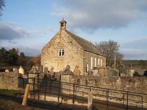
1809, plain rectangular church with long front elevation to
E, re-cast and altered in late 19th century. Rubble with
tooled rubble dressings. 6-bay main elevation with
round-headed entrance in outer SE bay (formerly mirrored by
similar in NE outer bay); 4 round-headed windows; 3 late
19th century round-headed windows; 3 late 19th century
round-headed window in rear W elevation; gallery window in
S gable. All fenestration with late 19th century cusped and
geometric tracery and leaded glazing. Birdcage bellcote
at S gable apex, ball finial at N; local slate roof.
Small Minister's room at N gable with entrance.
Interior: plain interior re-cast to N in late 19th
century. Pine plank (lowered) ceiling with stencil
decoration; gallery at S with round-headed detailing to
panelled front; pine plank dado; pine pews.
Burial ground: rubble walled rectangular burial ground;
entrance to S (to road) and W (to river) flanked by plain
square tooled granite gate piers with simple pyramidal caps.
18th and 19th century tombstones, many of local slate.
Simple square rubble watch-house with gable entrance, end
stack and local slate roof.
Ecclesiastical building in use as such. Site of parish church
"by no means convenient to the great bulk of the population".
Rear entrance to burial ground gives to river and Boat of
Cromdale ferry site.
Re-used datestone at wallhead above main entrance dated 1602
and initialled WG and EG.
External links are from the relevant listing authority and, where applicable, Wikidata. Wikidata IDs may be related buildings as well as this specific building. If you want to add or update a link, you will need to do so by editing the Wikidata entry.


Other nearby listed buildings
