Approximate Location Map
Large Map »
Latitude: 56.7668 / 56°46'0"N
Longitude: -3.8432 / 3°50'35"W
OS Eastings: 287433
OS Northings: 765428
OS Grid: NN874654
Mapcode National: GBR JBWT.VNB
Mapcode Global: WH4L4.Y52T
Plus Code: 9C8RQ584+PP
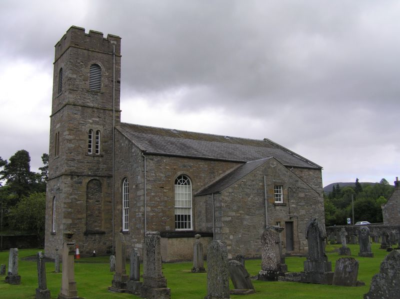
Entry Name: Blair Atholl And Struan Parish Church And Burial-Ground
Listing Name: Parish Church, Blair Atholl
Listing Date: 5 October 1971
Category: B
Source: Historic Scotland
Source ID: 337604
Historic Scotland Designation Reference: LB6101
Building Class: Cultural
ID on this website: 200337604
Location: Blair Atholl
County: Perth and Kinross
Electoral Ward: Highland
Parish: Blair Atholl
Traditional County: Perthshire
Tagged with: Church building Cemetery
Rectangular with 3-stage crenellated tower and
transeptal features. Rubble-built, severely plain,
original glazing. Archibald Elliot, archt., executed
posthumously 1823-5. Interior recast 1950.
Ecclesiastical building in use as such.
External links are from the relevant listing authority and, where applicable, Wikidata. Wikidata IDs may be related buildings as well as this specific building. If you want to add or update a link, you will need to do so by editing the Wikidata entry.


Other nearby listed buildings
