Approximate Location Map
Large Map »
Latitude: 57.4083 / 57°24'29"N
Longitude: -4.3288 / 4°19'43"W
OS Eastings: 260192
OS Northings: 837715
OS Grid: NH601377
Mapcode National: GBR H9P4.FVZ
Mapcode Global: WH3FP.G2W2
Plus Code: 9C9QCM5C+8F
Entry Name: Bona Lighthouse, Caledonian Canal
Listing Name: Bona Lighthouse, Caledonian Canal, Lochend
Listing Date: 5 October 1971
Category: B
Source: Historic Scotland
Source ID: 340077
Historic Scotland Designation Reference: LB8034
Building Class: Cultural
Also known as: Bona Narrows (Loch Ness) Light
Caledonian Canal, Bona Lighthouse
ID on this website: 200340077
Location: Inverness and Bona
County: Highland
Electoral Ward: Aird and Loch Ness
Parish: Inverness And Bona
Traditional County: Inverness-shire
Tagged with: Lighthouse
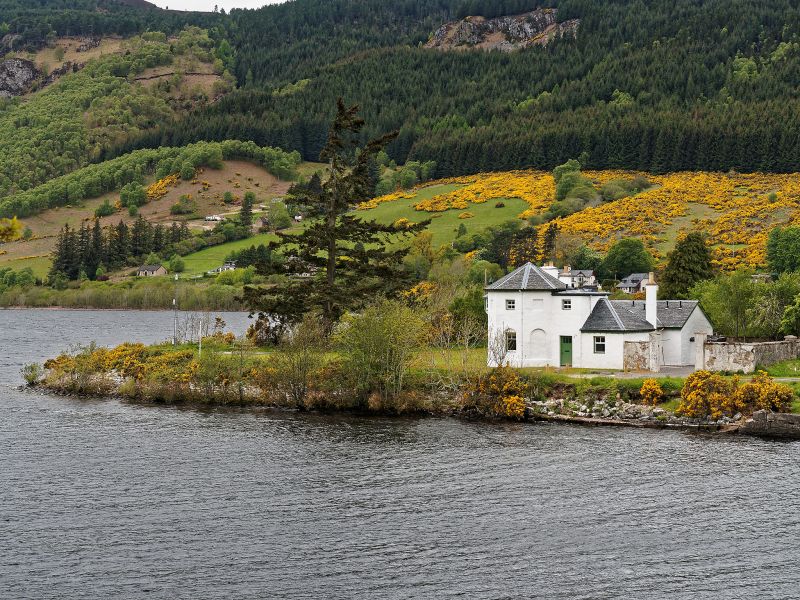
Thomas Telford, circa 1815, with alterations to form a lighthouse circa 1848. 2-storey octagonal former dwelling and lighthouse with various single-storey storage and stable additions extending to the north and east. The group is enclosed to the rear by a high coped rubble wall.
The buildings are predominantly all white rendered. There are shallow round-headed recesses to the octagonal ground floor with window openings in alternate bays. There are square recesses in the alternate first floor bays. A first floor oriel window to the west would have contained the former light. The slate roofs are predominantly piended. The former stable area is at the end of the north west range and it retains its setts and central drainage channel. There are three coped stacks with clay cans.
The interior was not seen in 2013. All the windows are boarded up.
Bona Lighthouse is a good example of an early canal related structure designed by renowned engineer Thomas Telford and it is an interesting and rare example of an inland light. It sits prominently on a peninsula on Loch Dochfour, at the north end of Loch Ness. It is an important part of the early history of the Caledonian canal.
The stretch of water where Bona Lighthouse sits is part of the route taken to access the canal, and is situated adjacent to the end of Loch Ness where the water narrows before flowing into Loch Dochfour. The channel at Bona, from Bon Ath, meaning white ford, was once a major crossing for drove roads. The small quay close to the building is situated at the site of the Bona Ferry crossing (following a General Wade road) through to Dores. By 1848 it was established as a pier for ferries and by 1864 it was replaced with stone. Telford and his colleagues would have been familiar with the site and its favourable setting due to the history of crossing here.
Between 1814 and 1818 the construction of the canal had stretched from Dochgarroch to reach Loch Ness, and the building at Bona was constructed at around this time. The building was first used as a dwelling house and store until 1848. As evidenced in the statement of significance produced by architectural firm LDN in 2009, originally there would have been a bedroom over a ground floor kitchen in the octagonal space, with a single storey store and stables to left, and single room to the rear. In 1844 canal engineers deepened and widened the Bona channel, and raised the level of the waters on the loch, marking the transition from horses pulling barges to steam tugs instead. There is evidence of stabling at Bona; original drawings in the report show four stables, indicating that this building may have been used as a stopping point along the canal. When improvements were carried out to the canal at Fort Augustus in 1847, the building at Bona would become a light shortly afterwards, and act as a visual aide to guide craft from Loch Ness into the narrow channel of the Caledonian Canal network.
Inland lights are uncommon in Scotland however a large proportion of those that are in existence are along the Caledonian Canal network: such as the pepper-pot lighthouses at Fort Augustus, Corpach and Gairlochy. Bona lighthouse may not have been purpose built for use as a light, but it was always intended to be a viewpoint even before it was adapted to hold light technology.
Intriguingly, the shape and form of the building at Bona is reminiscent of similar Telford construction of octagonal shaped tollhouses in Shropshire and on the road to Holyhead in Wales. Telford was involved in the upgrade to the main road, and many houses there share the same polygonal design. There is a very similar shaped tollhouse building attributed to Telford at Conan Bridge, and another near Tore. The position of Bona, at the pinch point of the river, with its protruding front bay and former stables, may suggest that the building was used as a toll prior to the light improvement however this has not been evidenced in research.
The whole of the Caledonian Canal is a Scheduled Monument which identifies it as being of national importance to Scotland. For this section of the Caledonian Canal see Scheduled Monument No 6498.
The Caledonian Canal is one of five canals surviving in Scotland but is unique among them as being the only one entirely funded by public money. The canal was part of a wider infrastructure initiative across the Highlands to facilitate trade and the growth of industry and, most importantly for the Government, to tackle the emigration problem resulting from the Highland Clearances, by providing much-needed employment. The experienced engineer Thomas Telford submitted a report in 1802 to Government commissioners which detailed the route and size of the canal. The canal connects Inverness in the north to Corpach, near Fort William in the west, by linking four lochs: Loch Dochfur, Loch Ness, Loch Oich and Loch Lochy. The total length of the canal is 60 miles, but only 22 miles are man-made.
Built to take sea-going ships, including the 32-gun and 44-gun frigates of the Royal Navy, the Caledonian Canal was designed on a much larger scale than other canals in Britain and the locks were the largest ever constructed at that time. This combined with the remoteness of the location and the variable ground conditions, make it a great feat of engineering and construction.
Telford was appointed principal engineer to the commission with William Jessop as consulting engineer. Although work began in 1804 rising costs and the scale of the project resulted in slow progress and the first complete journey was made on 23-24 October 1822. Whilst the Canal was constructed for commercial use it was never a commercial success. Since its opening it was beset by problems and had to be closed for repairs and improvements in the 1840s. However the canal became popular with passenger steamers with tourism increasing following a visit by Queen Victoria on 16 September 1873.
Listed building record updated as part of the Scottish Canals estate review (2013-14).
External links are from the relevant listing authority and, where applicable, Wikidata. Wikidata IDs may be related buildings as well as this specific building. If you want to add or update a link, you will need to do so by editing the Wikidata entry.


Other nearby listed buildings
