Approximate Location Map
Large Map »
Latitude: 56.4628 / 56°27'46"N
Longitude: -4.321 / 4°19'15"W
OS Eastings: 257090
OS Northings: 732490
OS Grid: NN570324
Mapcode National: GBR HCPM.ZCS
Mapcode Global: WH3L4.LTMD
Plus Code: 9C8QFM7H+4J
Entry Name: Dochart Mill, Killin
Listing Name: Killin, Breadalbane Folklore Centre, Former St Fillan's Mill
Listing Date: 5 October 1971
Category: B
Source: Historic Scotland
Source ID: 340376
Historic Scotland Designation Reference: LB8274
Building Class: Cultural
ID on this website: 200340376
Location: Killin
County: Stirling
Electoral Ward: Trossachs and Teith
Parish: Killin
Traditional County: Perthshire
Tagged with: Architectural structure
Loch Lomond and Trossachs National Park Planning Authority
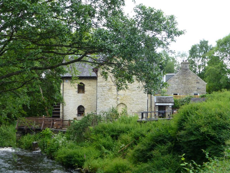
Constructed circa 1840, the Breadalbane Folklore Centre was a corn mill, later a tweed weaving mill and was converted to form a visitor centre in 1994. It was probably a replacement for an earlier mill on the site. Rubble-built with a creamy (lime)wash and pointed-arch openings in Breadalbane Gothick Estate style, the mill is prominently located in Killin and looks out over the renowned Falls of Dochart. The L-plan 3-storey mill serves as an important reminder of Killin's industrial history and its significant picturesque setting has ensured that it is a landmark in the village.
The West elevation is the entrance elevation and has a broad gabled section to the right with a small pitch-roofed projecting porch with the entrance in the re-entrant angle. Above are two floors with single light pointed-arch windows. Recessed to the left is a single bay with a pointed-arch door to the ground floor and a small window to the top floor with a pitched gable breaking the overhanging eaves. The East elevation which overlooks the Falls is a near mirror-image of this elevation with the replacement waterwheel where the porch is on the West elevation. The 1994 works added a parapet with timber decking to this part of the building.
INTERIOR
Comprehensively modernised to form the visitor centre, the interior walls are mostly bare or whitewashed stone. On the ground floor the mill mechanism is visible.
MATERIALS
Rubble stone, (lime) washed in places. Mostly modern replacement fixed light timber windows with mixture of small and large panes. Predominantly replacement timber boarded doors. Pitched slate roof with flat-topped ridge ventilator.
It is thought that the mill stopped weaving tweed in the 1950s. The mill is noted on the 1st edition Ordnance Survey map as 'Millinore (Corn)' and there is an adjoining building to the South West which is no longer extant and is desribed on the 2nd edition map as a 'Saw Mill' and the mill itself is called 'Corn Mill'.
External links are from the relevant listing authority and, where applicable, Wikidata. Wikidata IDs may be related buildings as well as this specific building. If you want to add or update a link, you will need to do so by editing the Wikidata entry.


Other nearby listed buildings
