Approximate Location Map
Large Map »
Latitude: 56.4359 / 56°26'9"N
Longitude: -2.8731 / 2°52'23"W
OS Eastings: 346260
OS Northings: 727416
OS Grid: NO462274
Mapcode National: GBR VN.5GM0
Mapcode Global: WH7RK.VH1K
Plus Code: 9C8VC4PG+8Q
Entry Name: Garpit Corn Mill, Tayport
Listing Name: Garpit Cornmill
Listing Date: 8 August 1973
Category: B
Source: Historic Scotland
Source ID: 341269
Historic Scotland Designation Reference: LB9022
Building Class: Cultural
ID on this website: 200341269
Location: Ferry Port On Craig
County: Fife
Electoral Ward: Tay Bridgehead
Parish: Ferry Port On Craig
Traditional County: Fife
Tagged with: Grain mill
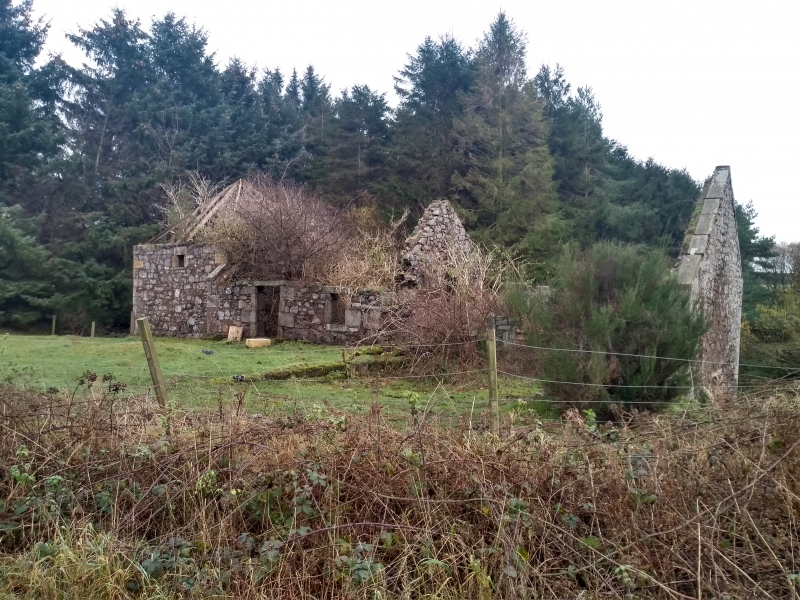
Dated 1817 at skew end. Low 2-storey sandstone rubble with ashlar dressings pantitled, raised kiln with pyramid roof. Wheel has been internal with tailrace arch; lower wing flanks tailrace at right angles. Ruinous, all workings and kiln gutted.
External links are from the relevant listing authority and, where applicable, Wikidata. Wikidata IDs may be related buildings as well as this specific building. If you want to add or update a link, you will need to do so by editing the Wikidata entry.


Other nearby listed buildings
