Approximate Location Map
Large Map »
Latitude: 55.0201 / 55°1'12"N
Longitude: -3.1332 / 3°7'59"W
OS Eastings: 327646
OS Northings: 570096
OS Grid: NY276700
Mapcode National: GBR 6BKD.G7
Mapcode Global: WH6Y8.V26T
Plus Code: 9C7R2VC8+3P
Entry Name: Kirkpatrick Fleming Parish Church
Listing Name: Kirkpatrick Fleming Parish Church and Churchyard Including Woodhouse Burial Enclosure
Listing Date: 3 August 1971
Category: B
Source: Historic Scotland
Source ID: 342134
Historic Scotland Designation Reference: LB9812
Building Class: Cultural
Also known as: Kirkpatrick-Fleming Parish Church
ID on this website: 200342134
Location: Kirkpatrick-Fleming
County: Dumfries and Galloway
Electoral Ward: Annandale East and Eskdale
Parish: Kirkpatrick-Fleming
Traditional County: Dumfriesshire
Tagged with: Church building
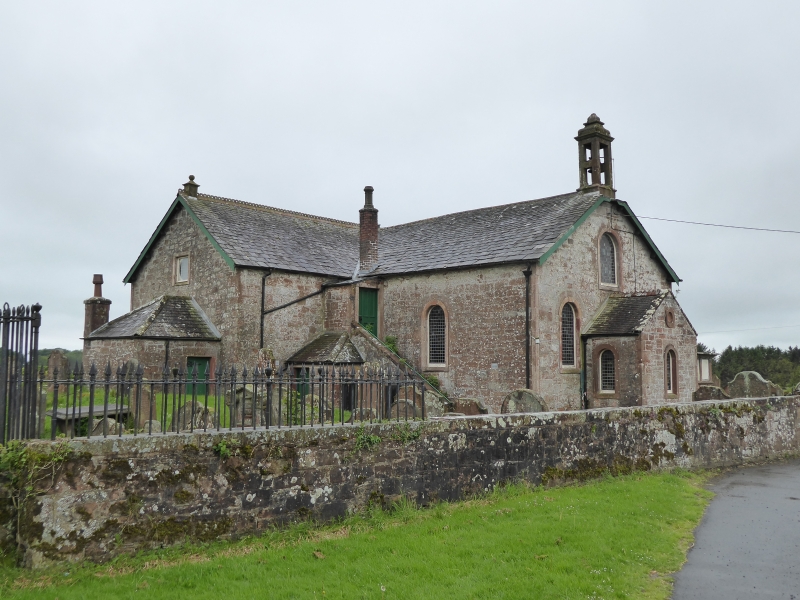
18th and 19th centuries. T-plan parish church with mainly
round-headed windows, gallery forestair and porches in
re-entrant angles, gable-head birdcage belfry over N jamb,
vestry and porch adjoin E and N gables respectively. 2 burial
enclosures (including fine renaissance Mossknowe enclosure -
listed separately) adjoin at W. Church built of red rubble,
ashlar dressings and margins; roofs covered with graded
slates, red ridging tiles, finials over E and W gables.
Suggested building sequence: E and W gables and N wall of
body of church probably 1733; "partly rebuilt" (NSA) circa
1778, i.e. (presumably) heightened several courses and long S
wall rebuilt (forming deeper plan church) with voussoired
key-stoned and aproned windows and narrow base course; N jamb
perhaps contemporary (though openings originally
square-headed). Renovated 1892 - N porch, roof with ridging
tiles and belfry all date from then.
INTERIOR: mostly probably by (?William) MacGowan, 1835. 3
galleries with panelled fronts and each supported on 2
slender cast-iron columns; octagonal pulpit central on south
wall, with round-arched back board.
CHURCHYARD: Circa 1796 rusticated Irving of Woodhouse
enclosure abuts jamb; red ashlar, white marble inscription
panels.
Plain red ashlar enclosure at SW end of churchyard.
Churchyard enclosed by ashlar-coped rubble built walls, gates
at N and at W with square gatepiers. Mainly 18th and 19th
century headstones.
Ecclesiastical building in use as such.
External links are from the relevant listing authority and, where applicable, Wikidata. Wikidata IDs may be related buildings as well as this specific building. If you want to add or update a link, you will need to do so by editing the Wikidata entry.


Other nearby listed buildings
