Approximate Location Map
Large Map »
Latitude: 56.0001 / 56°0'0"N
Longitude: -2.6526 / 2°39'9"W
OS Eastings: 359397
OS Northings: 678767
OS Grid: NT593787
Mapcode National: GBR 2X.TXPT
Mapcode Global: WH8VY.7G32
Plus Code: 9C8V282W+3X
Entry Name: East Range, Farmsteading, Smeaton House
Listing Name: Smeaton-Hepburn Farm Steading East Range
Listing Date: 2 May 1990
Category: B
Source: Historic Scotland
Source ID: 347889
Historic Scotland Designation Reference: LB14523
Building Class: Cultural
ID on this website: 200347889
Location: Prestonkirk
County: East Lothian
Electoral Ward: Dunbar and East Linton
Parish: Prestonkirk
Traditional County: East Lothian
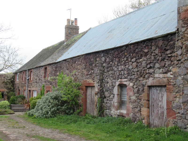
Mid-later 18th century. Granary with adjoining 2-storey
cottages, forming E range of U-plan steading; much
altered. Random whinstone rubble, mixed ashlar
dressings with broad droving, many stones renewed.
Granary with cart openings, possibly raised in early
19th century to provide loft. Cart-arch to outer left
now covered by modern door. Windows flanking; single bay
to left, 2 bays to right, now blocked. Granary loft
above with 3 small openings now blocked. Change in
masonry at quoins suggests possible raising.
S gable with cart-arch and 2 pitching holes above, now
blocked. Further pitching hole to loft.
At rear, loading doorway raised between floors with
smaller openings flanking, 3 windows to loft, now
blocked.
Lower range adjoining to left with 2 doorways and window
at ground floor, large modern sliding door at rear.
Range continuing to N. with 2 two storey farm cottages,
openings much altered; various glazing. Grey slates to
cartshed and granary and cottages; corrugated iron to
middle range. Straight skews; brick stack to cottages.
Unusual form for a granary; not multi-arched cartshed
with granary above. Possibly a girnal house for storing
landowner's grain; high doorways suggest grain may have
been stored on the sheaf, although it was more usually
stored on corn ricks out of doors.
External links are from the relevant listing authority and, where applicable, Wikidata. Wikidata IDs may be related buildings as well as this specific building. If you want to add or update a link, you will need to do so by editing the Wikidata entry.


Other nearby listed buildings
