Approximate Location Map
Large Map »
Latitude: 55.7918 / 55°47'30"N
Longitude: -3.34 / 3°20'23"W
OS Eastings: 316077
OS Northings: 656201
OS Grid: NT160562
Mapcode National: GBR 513G.PM
Mapcode Global: WH6T9.NPQ9
Plus Code: 9C7RQMR6+P2
Entry Name: Patie's Mill, Carlops
Listing Name: Carlops, Mill Lane, Patie's Mill Including Sundial
Listing Date: 22 January 1971
Category: B
Source: Historic Scotland
Source ID: 348077
Historic Scotland Designation Reference: LB14662
Building Class: Cultural
ID on this website: 200348077
Location: Penicuik
County: Scottish Borders
Electoral Ward: Tweeddale West
Parish: Penicuik
Traditional County: Peeblesshire
Tagged with: Mill building
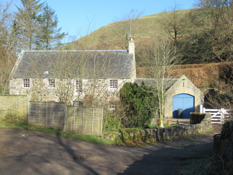
Dated 1800; converted for residential use 1964-5 by Stuart Harris; garage addition to N dated 1974. 2-storey, 4-bay, rectangular-plan, gable-roofed former mill located beside River North Esk at N end of Carlops village. Rubble with wrought sandstone dressings. Off-centre entrance with dated lintel stone. Cast-iron water wheel to NW gable.
Gabled, L-plan garage extension to NE: sandstone rubble with polished ashlar dressing; up-and-over timber door to segmental-arched opening with dated and monogramed key-stone; narrow louvred opening above.
Predominantly 12-pane glazing pattern to timber sash and case windows. 10-pane window to former high-level loading door over main entrance. Some 6-pane glazing to smaller openings to rear. Grey slate. Coped end stack to NE gable with clay cans. Ashlar skews. Cast-iron rainwater goods.
SUNDIAL: early 18th century. Chamferred plinth; Tuscan-columned shaft; cubed head with metal gnomen.
part of a B Group with 'Carlops, Mill Lane, Bridge Over River Esk At Patie's Mill' (Linton Parish - see separate listing).
A noteworthy example of an early rural mill, sympathetically converted for residential use. Picturesquely sited beside a waterfall of the North Esk at the N end of Carlops Village, the river powered a timber pitch-back water wheel to the rear gable, now replaced by a salvaged over-shot cast-iron wheel. Fragments of the earlier sluice system also survive adding further to the historic industrial context. The former mill and the associated segmental-arched rubble access bridge (see separate listing) contribute positively to their fine setting.
The lintel above the entrance of the building is dated 1800. Originally producing woollen felts for local paper mills and subsequently adapted for use as a corn mill, the building also later generated electricity for part of the village in the 1920s. As the North Esk serves as parish boundary, the former mill sits within the parish of Penicuik rather than the parish of Linton with the rest of Carlops Village. The fine early 18th century obelisk sundial with Tuscan column shaft in the garden was formerly at Prestonpans, East Lothian.
List description revised (2010).
External links are from the relevant listing authority and, where applicable, Wikidata. Wikidata IDs may be related buildings as well as this specific building. If you want to add or update a link, you will need to do so by editing the Wikidata entry.


Other nearby listed buildings
