Approximate Location Map
Large Map »
Latitude: 54.7761 / 54°46'33"N
Longitude: -4.4095 / 4°24'34"W
OS Eastings: 245120
OS Northings: 545014
OS Grid: NX451450
Mapcode National: GBR HJH2.LYB
Mapcode Global: WH3VF.76HX
Plus Code: 9C6QQHGR+C6
Entry Name: Farmhouse, Broughton Mains
Listing Name: Broughton Mains Farmhouse
Listing Date: 20 July 1972
Category: B
Source: Historic Scotland
Source ID: 350541
Historic Scotland Designation Reference: LB16740
Building Class: Cultural
ID on this website: 200350541
Location: Whithorn
County: Dumfries and Galloway
Electoral Ward: Mid Galloway and Wigtown West
Parish: Whithorn
Traditional County: Wigtownshire
Tagged with: Farmhouse
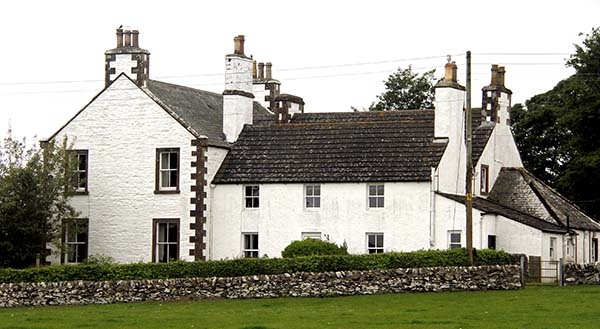
18th and 19th century. 2-storey farmhouse with 3 principal parts. To S main mid 19th century 3-bay front, to N 2 gabled wings, that to E late 18th century (original house) that to W mid 19th century.
S ELEVATION: painted rubble with roughcast short quoins and margins. Central pilastered doorpiece recessed door with fanlight. Flanking door single light windoww, 3 windows at 1st. All sash and case with 4-pane glazing. End skews with block skewputts, corniced end stacks with ocagonal cans. Slate roofs.
NE WING: formerly the original farmhouse incorporated as service wing of 19th century house. Lower 2-storey, 3-bay harled range with central window formerly door. All sash and case windows with 4-pane glazing upper window lintels on eaves level. To left, granite bay exposed fragment, red sandstone heraldic panel with initials I M dated 1628, panel reputedly reset from Old Place of Mochrum, the home of the Murreys of Broughton and Cally. Modern concrete tile roof, tall coped end stacks. NW WING: painted rtubble with raised margins similar in detail to S elevation. Modern concrete tile roof, tall corniced end stacks with octagonal cans. To both gables at N single storey rubble outshots.
External links are from the relevant listing authority and, where applicable, Wikidata. Wikidata IDs may be related buildings as well as this specific building. If you want to add or update a link, you will need to do so by editing the Wikidata entry.


Other nearby listed buildings
